You are here: Home > Network List > LD - Lamont-Doherty Cooperative Seismographic Network Stations List
> Station TRNY Table Rock, Ramapo, NY > Earthquake Result Viewer
TRNY Table Rock, Ramapo, NY - Earthquake Result Viewer
| Earthquake location: |
Off Coast Of Northern California |
| Earthquake latitude/longitude: |
40.5/-126.2 |
| Earthquake time(UTC): |
2016/12/08 (343) 14:49:46 GMT |
| Earthquake Depth: |
12 km |
| Earthquake Magnitude: |
6.5 Mwb |
| Earthquake Catalog/Contributor: |
NEIC PDE/us |
|
| Network: |
LD Lamont-Doherty Cooperative Seismographic Network |
| Station: |
TRNY Table Rock, Ramapo, NY |
| Lat/Lon: |
41.15 N/74.22 W |
| Elevation: |
270 m |
|
| Distance: |
38.8 deg |
| Az: |
71.505 deg |
| Baz: |
286.685 deg |
| Ray Param: |
0.07533365 |
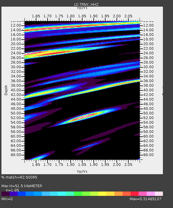
| Estimated Moho Depth: |
51.5 km |
| Estimated Crust Vp/Vs: |
1.85 |
| Assumed Crust Vp: |
6.283 km/s |
| Estimated Crust Vs: |
3.396 km/s |
| Estimated Crust Poisson's Ratio: |
0.29 |
|
| Radial Match: |
92.50095 % |
| Radial Bump: |
341 |
| Transverse Match: |
74.43718 % |
| Transverse Bump: |
400 |
| SOD ConfigId: |
11737051 |
| Insert Time: |
2019-04-26 05:52:50.828 +0000 |
| GWidth: |
2.5 |
| Max Bumps: |
400 |
| Tol: |
0.001 |
|

Signal To Noise
| Channel | StoN | STA | LTA |
| LD:TRNY: :HHZ:20161208T14:56:40.569996Z | 5.2338715 | 1.0280253E-6 | 1.9641773E-7 |
| LD:TRNY: :HHN:20161208T14:56:40.569996Z | 1.3078085 | 2.8537755E-7 | 2.1821052E-7 |
| LD:TRNY: :HHE:20161208T14:56:40.569996Z | 2.7986093 | 5.714608E-7 | 2.0419458E-7 |
| Arrivals |
| Ps | 7.4 SECOND |
| PpPs | 22 SECOND |
| PsPs/PpSs | 29 SECOND |


