You are here: Home > Network List > CI - Caltech Regional Seismic Network Stations List
> Station FUR Furnace Creek, CA, USA > Earthquake Result Viewer
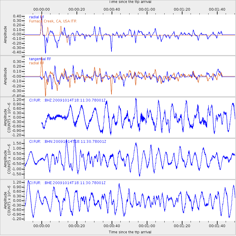
FUR Furnace Creek, CA, USA - Earthquake Result Viewer
*The percent match for this event was below the threshold and hence no stack was calculated.
| Earthquake location: |
Samoa Islands Region |
| Earthquake latitude/longitude: |
-14.9/-174.8 |
| Earthquake time(UTC): |
2009/10/14 (287) 18:00:21 GMT |
| Earthquake Depth: |
10 km |
| Earthquake Magnitude: |
5.7 MB, 6.0 MS, 6.3 MW, 6.2 MW |
| Earthquake Catalog/Contributor: |
WHDF/NEIC |
|
| Network: |
CI Caltech Regional Seismic Network |
| Station: |
FUR Furnace Creek, CA, USA |
| Lat/Lon: |
36.47 N/116.86 W |
| Elevation: |
-37.0 m |
|
| Distance: |
74.8 deg |
| Az: |
45.078 deg |
| Baz: |
238.124 deg |
| Ray Param: |
$rayparam |
*The percent match for this event was below the threshold and hence was not used in the summary stack. |
|
| Radial Match: |
75.48672 % |
| Radial Bump: |
400 |
| Transverse Match: |
54.513275 % |
| Transverse Bump: |
400 |
| SOD ConfigId: |
2622 |
| Insert Time: |
2010-03-05 20:17:12.158 +0000 |
| GWidth: |
2.5 |
| Max Bumps: |
400 |
| Tol: |
0.001 |
|
Signal To Noise
| Channel | StoN | STA | LTA |
| CI:FUR: :BHN:20091014T18:11:30.78001Z | 1.2584728 | 4.5247944E-7 | 3.5954648E-7 |
| CI:FUR: :BHE:20091014T18:11:30.78001Z | 0.6213974 | 2.7946442E-7 | 4.497354E-7 |
| CI:FUR: :BHZ:20091014T18:11:30.78001Z | 1.8661488 | 6.4654705E-7 | 3.4646058E-7 |
| Arrivals |
| Ps | |
| PpPs | |
| PsPs/PpSs | |


