You are here: Home > Network List > N4 - Central and EAstern US Network Stations List
> Station I49A Point Hope, MI, USA > Earthquake Result Viewer
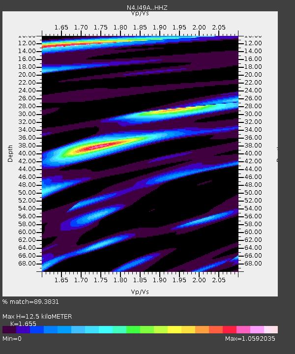
I49A Point Hope, MI, USA - Earthquake Result Viewer
| Earthquake location: |
Off Coast Of Northern California |
| Earthquake latitude/longitude: |
40.5/-126.2 |
| Earthquake time(UTC): |
2016/12/08 (343) 14:49:46 GMT |
| Earthquake Depth: |
12 km |
| Earthquake Magnitude: |
6.5 Mwb |
| Earthquake Catalog/Contributor: |
NEIC PDE/us |
|
| Network: |
N4 Central and EAstern US Network |
| Station: |
I49A Point Hope, MI, USA |
| Lat/Lon: |
43.94 N/82.82 W |
| Elevation: |
217 m |
|
| Distance: |
32.0 deg |
| Az: |
69.259 deg |
| Baz: |
279.051 deg |
| Ray Param: |
0.07883048 |
| Estimated Moho Depth: |
12.5 km |
| Estimated Crust Vp/Vs: |
1.65 |
| Assumed Crust Vp: |
6.483 km/s |
| Estimated Crust Vs: |
3.917 km/s |
| Estimated Crust Poisson's Ratio: |
0.21 |
|
| Radial Match: |
89.3831 % |
| Radial Bump: |
371 |
| Transverse Match: |
76.8375 % |
| Transverse Bump: |
400 |
| SOD ConfigId: |
11737051 |
| Insert Time: |
2019-04-26 05:53:18.557 +0000 |
| GWidth: |
2.5 |
| Max Bumps: |
400 |
| Tol: |
0.001 |
|

Signal To Noise
| Channel | StoN | STA | LTA |
| N4:I49A: :HHZ:20161208T14:55:42.120015Z | 2.7985196 | 1.591131E-6 | 5.685617E-7 |
| N4:I49A: :HHN:20161208T14:55:42.120015Z | 0.95142126 | 2.976029E-7 | 3.1279822E-7 |
| N4:I49A: :HHE:20161208T14:55:42.120015Z | 2.5871713 | 8.3373504E-7 | 3.2225736E-7 |
| Arrivals |
| Ps | 1.4 SECOND |
| PpPs | 4.7 SECOND |
| PsPs/PpSs | 6.1 SECOND |


