You are here: Home > Network List > N4 - Central and EAstern US Network Stations List
> Station K62A Royalston, MA, USA > Earthquake Result Viewer
K62A Royalston, MA, USA - Earthquake Result Viewer
| Earthquake location: |
Off Coast Of Northern California |
| Earthquake latitude/longitude: |
40.5/-126.2 |
| Earthquake time(UTC): |
2016/12/08 (343) 14:49:46 GMT |
| Earthquake Depth: |
12 km |
| Earthquake Magnitude: |
6.5 Mwb |
| Earthquake Catalog/Contributor: |
NEIC PDE/us |
|
| Network: |
N4 Central and EAstern US Network |
| Station: |
K62A Royalston, MA, USA |
| Lat/Lon: |
42.67 N/72.23 W |
| Elevation: |
289 m |
|
| Distance: |
39.8 deg |
| Az: |
68.549 deg |
| Baz: |
285.723 deg |
| Ray Param: |
0.07475134 |
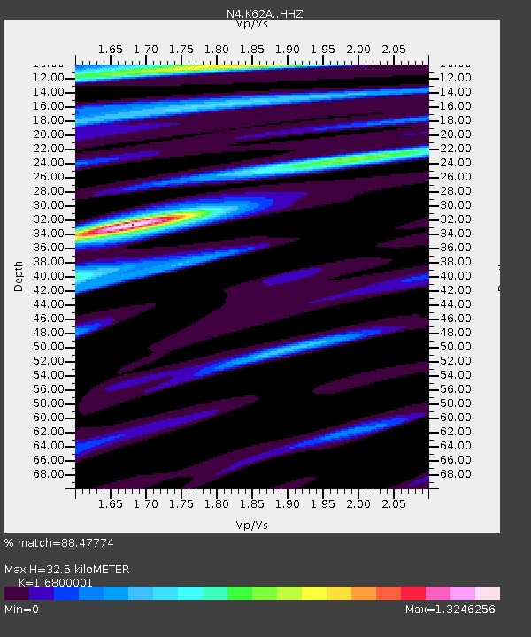
| Estimated Moho Depth: |
32.5 km |
| Estimated Crust Vp/Vs: |
1.68 |
| Assumed Crust Vp: |
6.419 km/s |
| Estimated Crust Vs: |
3.821 km/s |
| Estimated Crust Poisson's Ratio: |
0.23 |
|
| Radial Match: |
88.47774 % |
| Radial Bump: |
350 |
| Transverse Match: |
68.19571 % |
| Transverse Bump: |
400 |
| SOD ConfigId: |
11737051 |
| Insert Time: |
2019-04-26 05:53:28.000 +0000 |
| GWidth: |
2.5 |
| Max Bumps: |
400 |
| Tol: |
0.001 |
|

Signal To Noise
| Channel | StoN | STA | LTA |
| N4:K62A: :HHZ:20161208T14:56:48.930012Z | 2.1935537 | 6.456733E-7 | 2.9435034E-7 |
| N4:K62A: :HHN:20161208T14:56:48.930012Z | 1.6614586 | 3.2334503E-7 | 1.9461517E-7 |
| N4:K62A: :HHE:20161208T14:56:48.930012Z | 1.3068318 | 2.9580468E-7 | 2.2635253E-7 |
| Arrivals |
| Ps | 3.7 SECOND |
| PpPs | 13 SECOND |
| PsPs/PpSs | 16 SECOND |


