You are here: Home > Network List > N4 - Central and EAstern US Network Stations List
> Station N49A Columbus Grove, OH, USA > Earthquake Result Viewer
N49A Columbus Grove, OH, USA - Earthquake Result Viewer
| Earthquake location: |
Off Coast Of Northern California |
| Earthquake latitude/longitude: |
40.5/-126.2 |
| Earthquake time(UTC): |
2016/12/08 (343) 14:49:46 GMT |
| Earthquake Depth: |
12 km |
| Earthquake Magnitude: |
6.5 Mwb |
| Earthquake Catalog/Contributor: |
NEIC PDE/us |
|
| Network: |
N4 Central and EAstern US Network |
| Station: |
N49A Columbus Grove, OH, USA |
| Lat/Lon: |
40.92 N/84.18 W |
| Elevation: |
225 m |
|
| Distance: |
31.6 deg |
| Az: |
75.244 deg |
| Baz: |
283.225 deg |
| Ray Param: |
0.07900243 |
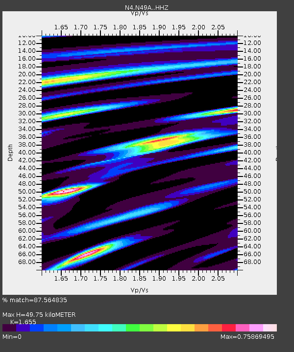
| Estimated Moho Depth: |
49.75 km |
| Estimated Crust Vp/Vs: |
1.65 |
| Assumed Crust Vp: |
6.498 km/s |
| Estimated Crust Vs: |
3.926 km/s |
| Estimated Crust Poisson's Ratio: |
0.21 |
|
| Radial Match: |
87.564835 % |
| Radial Bump: |
288 |
| Transverse Match: |
69.892044 % |
| Transverse Bump: |
400 |
| SOD ConfigId: |
11737051 |
| Insert Time: |
2019-04-26 05:53:36.114 +0000 |
| GWidth: |
2.5 |
| Max Bumps: |
400 |
| Tol: |
0.001 |
|

Signal To Noise
| Channel | StoN | STA | LTA |
| N4:N49A: :HHZ:20161208T14:55:38.580006Z | 6.0601254 | 1.192657E-6 | 1.9680401E-7 |
| N4:N49A: :HHN:20161208T14:55:38.580006Z | 2.8533309 | 4.3519307E-7 | 1.5252107E-7 |
| N4:N49A: :HHE:20161208T14:55:38.580006Z | 7.7002916 | 8.2073166E-7 | 1.0658449E-7 |
| Arrivals |
| Ps | 5.5 SECOND |
| PpPs | 19 SECOND |
| PsPs/PpSs | 24 SECOND |


