You are here: Home > Network List > N4 - Central and EAstern US Network Stations List
> Station R53A Hurricane, WV, USA > Earthquake Result Viewer
R53A Hurricane, WV, USA - Earthquake Result Viewer
| Earthquake location: |
Off Coast Of Northern California |
| Earthquake latitude/longitude: |
40.5/-126.2 |
| Earthquake time(UTC): |
2016/12/08 (343) 14:49:46 GMT |
| Earthquake Depth: |
12 km |
| Earthquake Magnitude: |
6.5 Mwb |
| Earthquake Catalog/Contributor: |
NEIC PDE/us |
|
| Network: |
N4 Central and EAstern US Network |
| Station: |
R53A Hurricane, WV, USA |
| Lat/Lon: |
38.33 N/81.95 W |
| Elevation: |
294 m |
|
| Distance: |
34.0 deg |
| Az: |
78.999 deg |
| Baz: |
287.8 deg |
| Ray Param: |
0.07796433 |
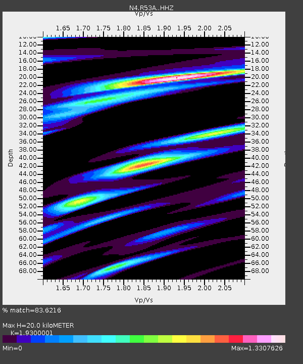
| Estimated Moho Depth: |
20.0 km |
| Estimated Crust Vp/Vs: |
1.93 |
| Assumed Crust Vp: |
6.207 km/s |
| Estimated Crust Vs: |
3.216 km/s |
| Estimated Crust Poisson's Ratio: |
0.32 |
|
| Radial Match: |
83.6216 % |
| Radial Bump: |
400 |
| Transverse Match: |
66.12776 % |
| Transverse Bump: |
400 |
| SOD ConfigId: |
11737051 |
| Insert Time: |
2019-04-26 05:53:51.018 +0000 |
| GWidth: |
2.5 |
| Max Bumps: |
400 |
| Tol: |
0.001 |
|

Signal To Noise
| Channel | StoN | STA | LTA |
| N4:R53A: :HHZ:20161208T14:55:59.099995Z | 2.4007077 | 7.6030966E-7 | 3.167023E-7 |
| N4:R53A: :HHN:20161208T14:55:59.099995Z | 0.837625 | 2.4634224E-7 | 2.9409608E-7 |
| N4:R53A: :HHE:20161208T14:55:59.099995Z | 1.7889017 | 5.84371E-7 | 3.266647E-7 |
| Arrivals |
| Ps | 3.2 SECOND |
| PpPs | 8.8 SECOND |
| PsPs/PpSs | 12 SECOND |


