You are here: Home > Network List > N4 - Central and EAstern US Network Stations List
> Station R58B Mineral, VA, USA > Earthquake Result Viewer
R58B Mineral, VA, USA - Earthquake Result Viewer
| Earthquake location: |
Off Coast Of Northern California |
| Earthquake latitude/longitude: |
40.5/-126.2 |
| Earthquake time(UTC): |
2016/12/08 (343) 14:49:46 GMT |
| Earthquake Depth: |
12 km |
| Earthquake Magnitude: |
6.5 Mwb |
| Earthquake Catalog/Contributor: |
NEIC PDE/us |
|
| Network: |
N4 Central and EAstern US Network |
| Station: |
R58B Mineral, VA, USA |
| Lat/Lon: |
37.96 N/77.88 W |
| Elevation: |
116 m |
|
| Distance: |
37.1 deg |
| Az: |
77.836 deg |
| Baz: |
289.36 deg |
| Ray Param: |
0.07630535 |
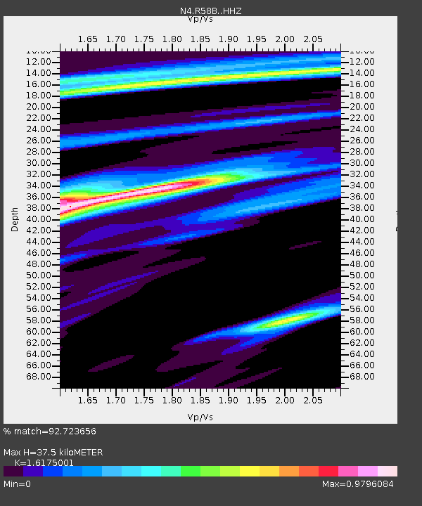
| Estimated Moho Depth: |
37.5 km |
| Estimated Crust Vp/Vs: |
1.62 |
| Assumed Crust Vp: |
6.565 km/s |
| Estimated Crust Vs: |
4.058 km/s |
| Estimated Crust Poisson's Ratio: |
0.19 |
|
| Radial Match: |
92.723656 % |
| Radial Bump: |
285 |
| Transverse Match: |
66.496376 % |
| Transverse Bump: |
400 |
| SOD ConfigId: |
11737051 |
| Insert Time: |
2019-04-26 05:53:52.684 +0000 |
| GWidth: |
2.5 |
| Max Bumps: |
400 |
| Tol: |
0.001 |
|

Signal To Noise
| Channel | StoN | STA | LTA |
| N4:R58B: :HHZ:20161208T14:56:26.189991Z | 1.9935316 | 5.7488984E-7 | 2.883776E-7 |
| N4:R58B: :HHN:20161208T14:56:26.189991Z | 0.71173114 | 1.509027E-7 | 2.1202204E-7 |
| N4:R58B: :HHE:20161208T14:56:26.189991Z | 0.91346365 | 2.278633E-7 | 2.4944978E-7 |
| Arrivals |
| Ps | 3.8 SECOND |
| PpPs | 14 SECOND |
| PsPs/PpSs | 18 SECOND |


