You are here: Home > Network List > OV - Observatorio Vulcanolżgico y Sismolżgico de Costa Rica Stations List
> Station INDI Punta Indio, Guanacaste > Earthquake Result Viewer
INDI Punta Indio, Guanacaste - Earthquake Result Viewer
| Earthquake location: |
Off Coast Of Northern California |
| Earthquake latitude/longitude: |
40.5/-126.2 |
| Earthquake time(UTC): |
2016/12/08 (343) 14:49:46 GMT |
| Earthquake Depth: |
12 km |
| Earthquake Magnitude: |
6.5 Mwb |
| Earthquake Catalog/Contributor: |
NEIC PDE/us |
|
| Network: |
OV Observatorio Vulcanolżgico y Sismolżgico de Costa Rica |
| Station: |
INDI Punta Indio, Guanacaste |
| Lat/Lon: |
9.87 N/85.50 W |
| Elevation: |
74 m |
|
| Distance: |
47.1 deg |
| Az: |
118.844 deg |
| Baz: |
317.305 deg |
| Ray Param: |
0.07019198 |
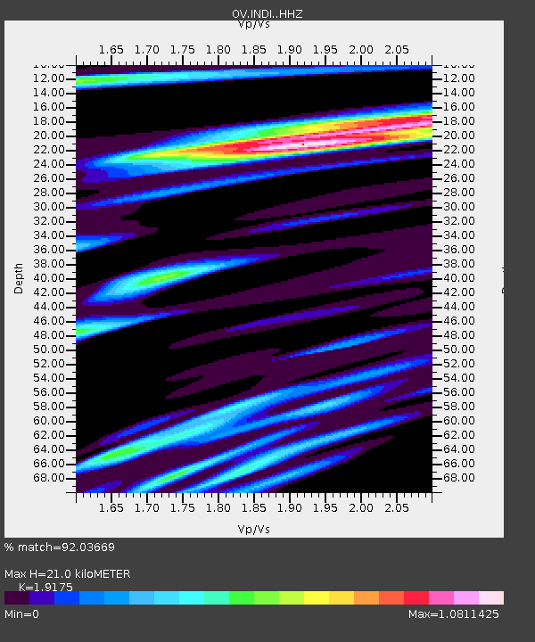
| Estimated Moho Depth: |
21.0 km |
| Estimated Crust Vp/Vs: |
1.92 |
| Assumed Crust Vp: |
6.183 km/s |
| Estimated Crust Vs: |
3.224 km/s |
| Estimated Crust Poisson's Ratio: |
0.31 |
|
| Radial Match: |
92.03669 % |
| Radial Bump: |
400 |
| Transverse Match: |
88.59511 % |
| Transverse Bump: |
400 |
| SOD ConfigId: |
11737051 |
| Insert Time: |
2019-04-26 05:54:38.971 +0000 |
| GWidth: |
2.5 |
| Max Bumps: |
400 |
| Tol: |
0.001 |
|

Signal To Noise
| Channel | StoN | STA | LTA |
| OV:INDI: :HHZ:20161208T14:57:47.700001Z | 7.07618 | 6.7906234E-7 | 9.596454E-8 |
| OV:INDI: :HHN:20161208T14:57:47.700001Z | 2.2222092 | 2.6298972E-7 | 1.18346065E-7 |
| OV:INDI: :HHE:20161208T14:57:47.700001Z | 2.4332116 | 1.5783937E-7 | 6.486874E-8 |
| Arrivals |
| Ps | 3.3 SECOND |
| PpPs | 9.4 SECOND |
| PsPs/PpSs | 13 SECOND |


