You are here: Home > Network List > G - GEOSCOPE Stations List
> Station PPTF Pamatai - Papeete - Tahiti island - French Polynesia, France > Earthquake Result Viewer
PPTF Pamatai - Papeete - Tahiti island - French Polynesia, France - Earthquake Result Viewer
| Earthquake location: |
Vanuatu Islands |
| Earthquake latitude/longitude: |
-14.8/167.3 |
| Earthquake time(UTC): |
2015/10/20 (293) 21:52:02 GMT |
| Earthquake Depth: |
127 km |
| Earthquake Magnitude: |
7.1 MWW, 7.3 MI |
| Earthquake Catalog/Contributor: |
NEIC PDE/NEIC COMCAT |
|
| Network: |
G GEOSCOPE |
| Station: |
PPTF Pamatai - Papeete - Tahiti island - French Polynesia, France |
| Lat/Lon: |
17.59 S/149.57 W |
| Elevation: |
705 m |
|
| Distance: |
41.4 deg |
| Az: |
99.854 deg |
| Baz: |
267.332 deg |
| Ray Param: |
0.07332192 |
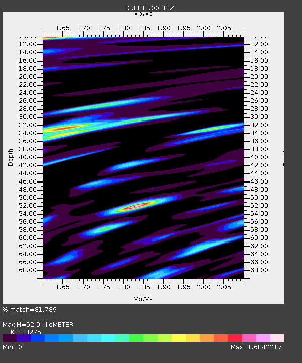
| Estimated Moho Depth: |
52.0 km |
| Estimated Crust Vp/Vs: |
1.83 |
| Assumed Crust Vp: |
4.24 km/s |
| Estimated Crust Vs: |
2.32 km/s |
| Estimated Crust Poisson's Ratio: |
0.29 |
|
| Radial Match: |
81.789 % |
| Radial Bump: |
400 |
| Transverse Match: |
65.4146 % |
| Transverse Bump: |
400 |
| SOD ConfigId: |
1259291 |
| Insert Time: |
2015-11-03 22:18:42.208 +0000 |
| GWidth: |
2.5 |
| Max Bumps: |
400 |
| Tol: |
0.001 |
|

Signal To Noise
| Channel | StoN | STA | LTA |
| G:PPTF:00:BHZ:20151020T21:59:05.750012Z | 15.2245035 | 5.0940773E-5 | 3.3459726E-6 |
| G:PPTF:00:BHN:20151020T21:59:05.750012Z | 1.6495469 | 4.798929E-6 | 2.9092407E-6 |
| G:PPTF:00:BHE:20151020T21:59:05.750012Z | 13.456674 | 2.851248E-5 | 2.1188357E-6 |
| Arrivals |
| Ps | 10 SECOND |
| PpPs | 34 SECOND |
| PsPs/PpSs | 44 SECOND |


