You are here: Home > Network List > CI - Caltech Regional Seismic Network Stations List
> Station FUR Furnace Creek, CA, USA > Earthquake Result Viewer
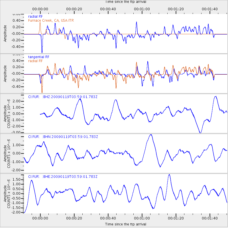
FUR Furnace Creek, CA, USA - Earthquake Result Viewer
*The percent match for this event was below the threshold and hence no stack was calculated.
| Earthquake location: |
Southeast Of Loyalty Islands |
| Earthquake latitude/longitude: |
-22.5/170.8 |
| Earthquake time(UTC): |
2009/01/19 (019) 03:46:37 GMT |
| Earthquake Depth: |
35 km |
| Earthquake Magnitude: |
6.0 MW, 5.3 MB |
| Earthquake Catalog/Contributor: |
WHDF/NEIC |
|
| Network: |
CI Caltech Regional Seismic Network |
| Station: |
FUR Furnace Creek, CA, USA |
| Lat/Lon: |
36.47 N/116.86 W |
| Elevation: |
-37.0 m |
|
| Distance: |
89.9 deg |
| Az: |
50.181 deg |
| Baz: |
241.8 deg |
| Ray Param: |
$rayparam |
*The percent match for this event was below the threshold and hence was not used in the summary stack. |
|
| Radial Match: |
51.99642 % |
| Radial Bump: |
400 |
| Transverse Match: |
45.38127 % |
| Transverse Bump: |
391 |
| SOD ConfigId: |
2658 |
| Insert Time: |
2010-03-05 20:17:44.536 +0000 |
| GWidth: |
2.5 |
| Max Bumps: |
400 |
| Tol: |
0.001 |
|
Signal To Noise
| Channel | StoN | STA | LTA |
| CI:FUR: :BHN:20090119T03:59:01.783Z | 2.9446893 | 1.1216798E-6 | 3.809162E-7 |
| CI:FUR: :BHE:20090119T03:59:01.783Z | 0.50412625 | 4.2501011E-7 | 8.430629E-7 |
| CI:FUR: :BHZ:20090119T03:59:01.783Z | 1.1867594 | 1.0027767E-6 | 8.449705E-7 |
| Arrivals |
| Ps | |
| PpPs | |
| PsPs/PpSs | |


