You are here: Home > Network List > CI - Caltech Regional Seismic Network Stations List
> Station FUR Furnace Creek, CA, USA > Earthquake Result Viewer
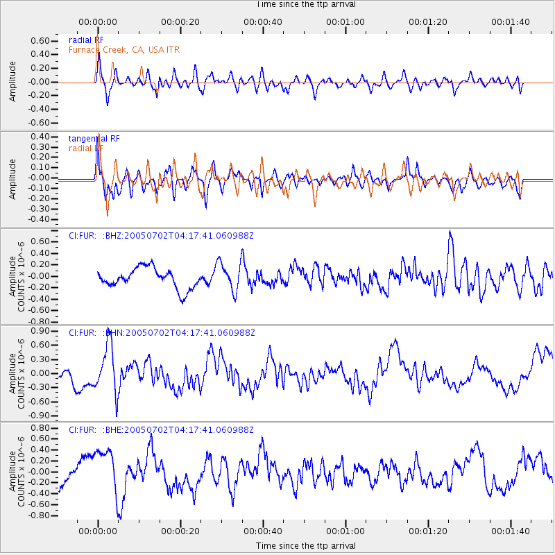
FUR Furnace Creek, CA, USA - Earthquake Result Viewer
*The percent match for this event was below the threshold and hence no stack was calculated.
| Earthquake location: |
Near Coast Of Nicaragua |
| Earthquake latitude/longitude: |
11.4/-86.3 |
| Earthquake time(UTC): |
2005/07/02 (183) 04:11:04 GMT |
| Earthquake Depth: |
40 km |
| Earthquake Magnitude: |
5.4 MB, 5.4 MS, 5.8 MW, 5.0 MD |
| Earthquake Catalog/Contributor: |
WHDF/NEIC |
|
| Network: |
CI Caltech Regional Seismic Network |
| Station: |
FUR Furnace Creek, CA, USA |
| Lat/Lon: |
36.47 N/116.86 W |
| Elevation: |
-37.0 m |
|
| Distance: |
37.2 deg |
| Az: |
317.241 deg |
| Baz: |
124.33 deg |
| Ray Param: |
$rayparam |
*The percent match for this event was below the threshold and hence was not used in the summary stack. |
|
| Radial Match: |
63.94431 % |
| Radial Bump: |
400 |
| Transverse Match: |
60.017845 % |
| Transverse Bump: |
400 |
| SOD ConfigId: |
3128 |
| Insert Time: |
2010-03-05 20:17:46.552 +0000 |
| GWidth: |
2.5 |
| Max Bumps: |
400 |
| Tol: |
0.001 |
|
Signal To Noise
| Channel | StoN | STA | LTA |
| CI:FUR: :BHN:20050702T04:17:41.060988Z | 4.1825047 | 5.209926E-7 | 1.2456474E-7 |
| CI:FUR: :BHE:20050702T04:17:41.060988Z | 1.8280497 | 4.3350047E-7 | 2.3713825E-7 |
| CI:FUR: :BHZ:20050702T04:17:41.060988Z | 1.438073 | 2.5094525E-7 | 1.7450104E-7 |
| Arrivals |
| Ps | |
| PpPs | |
| PsPs/PpSs | |


