You are here: Home > Network List > AK - Alaska Regional Network Stations List
> Station UNV Unalaska Valley > Earthquake Result Viewer
UNV Unalaska Valley - Earthquake Result Viewer
| Earthquake location: |
Solomon Islands |
| Earthquake latitude/longitude: |
-10.7/161.3 |
| Earthquake time(UTC): |
2016/12/08 (343) 17:38:46 GMT |
| Earthquake Depth: |
41 km |
| Earthquake Magnitude: |
7.8 mww |
| Earthquake Catalog/Contributor: |
NEIC PDE/us |
|
| Network: |
AK Alaska Regional Network |
| Station: |
UNV Unalaska Valley |
| Lat/Lon: |
53.85 N/166.50 W |
| Elevation: |
67 m |
|
| Distance: |
69.8 deg |
| Az: |
19.638 deg |
| Baz: |
213.882 deg |
| Ray Param: |
0.055310275 |
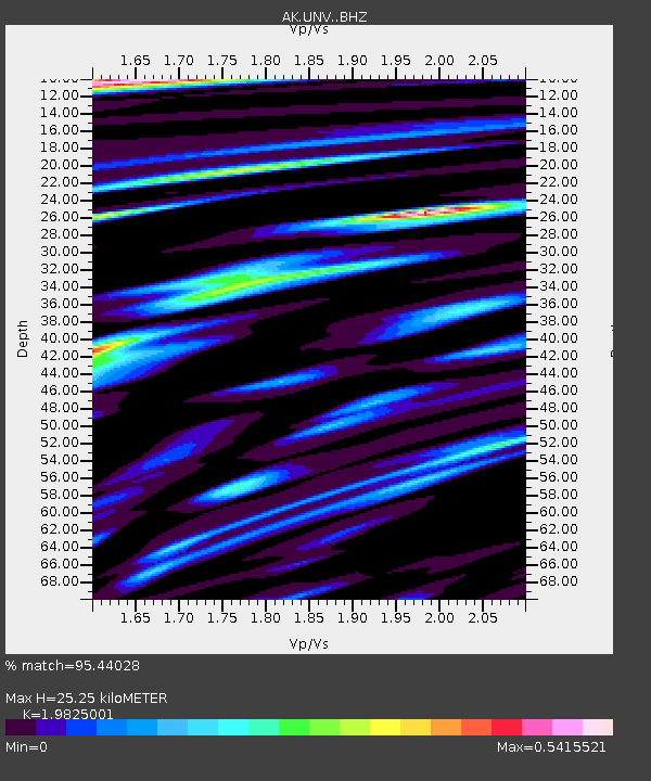
| Estimated Moho Depth: |
25.25 km |
| Estimated Crust Vp/Vs: |
1.98 |
| Assumed Crust Vp: |
3.943 km/s |
| Estimated Crust Vs: |
1.989 km/s |
| Estimated Crust Poisson's Ratio: |
0.33 |
|
| Radial Match: |
95.44028 % |
| Radial Bump: |
310 |
| Transverse Match: |
86.899124 % |
| Transverse Bump: |
400 |
| SOD ConfigId: |
11737051 |
| Insert Time: |
2019-04-26 05:58:39.267 +0000 |
| GWidth: |
2.5 |
| Max Bumps: |
400 |
| Tol: |
0.001 |
|

Signal To Noise
| Channel | StoN | STA | LTA |
| AK:UNV: :BHZ:20161208T17:49:21.867976Z | 10.60293 | 7.827008E-6 | 7.381929E-7 |
| AK:UNV: :BHN:20161208T17:49:21.867976Z | 4.47143 | 3.5900628E-6 | 8.028892E-7 |
| AK:UNV: :BHE:20161208T17:49:21.867976Z | 3.5624847 | 2.1561225E-6 | 6.0522996E-7 |
| Arrivals |
| Ps | 6.4 SECOND |
| PpPs | 19 SECOND |
| PsPs/PpSs | 25 SECOND |


