You are here: Home > Network List > IU - Global Seismograph Network (GSN - IRIS/USGS) Stations List
> Station GUMO Guam, Mariana Islands > Earthquake Result Viewer
GUMO Guam, Mariana Islands - Earthquake Result Viewer
| Earthquake location: |
Vanuatu Islands |
| Earthquake latitude/longitude: |
-14.8/167.3 |
| Earthquake time(UTC): |
2015/10/20 (293) 21:52:02 GMT |
| Earthquake Depth: |
127 km |
| Earthquake Magnitude: |
7.1 MWW, 7.3 MI |
| Earthquake Catalog/Contributor: |
NEIC PDE/NEIC COMCAT |
|
| Network: |
IU Global Seismograph Network (GSN - IRIS/USGS) |
| Station: |
GUMO Guam, Mariana Islands |
| Lat/Lon: |
13.59 N/144.87 E |
| Elevation: |
170 m |
|
| Distance: |
35.9 deg |
| Az: |
320.77 deg |
| Baz: |
141.024 deg |
| Ray Param: |
0.07652474 |
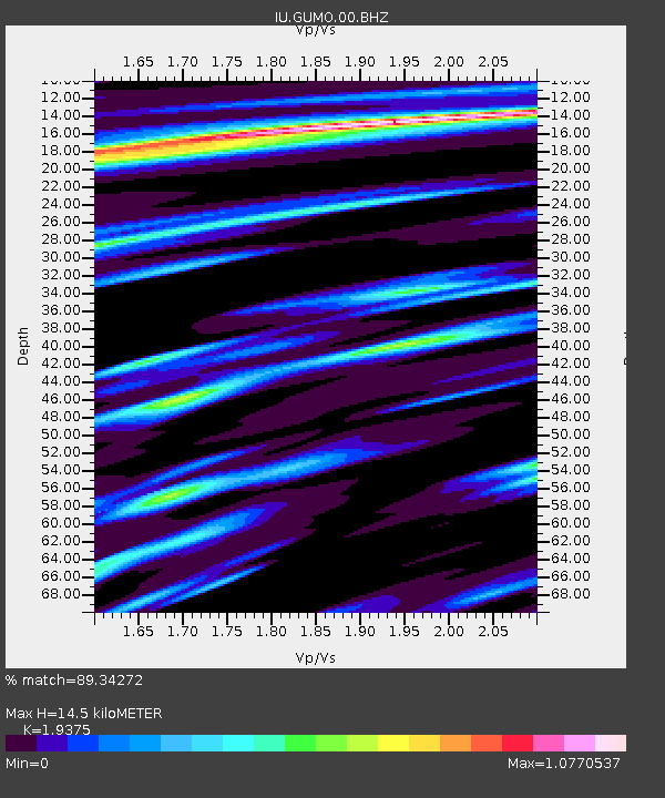
| Estimated Moho Depth: |
14.5 km |
| Estimated Crust Vp/Vs: |
1.94 |
| Assumed Crust Vp: |
4.802 km/s |
| Estimated Crust Vs: |
2.478 km/s |
| Estimated Crust Poisson's Ratio: |
0.32 |
|
| Radial Match: |
89.34272 % |
| Radial Bump: |
319 |
| Transverse Match: |
72.87731 % |
| Transverse Bump: |
400 |
| SOD ConfigId: |
1259291 |
| Insert Time: |
2015-11-03 22:19:39.179 +0000 |
| GWidth: |
2.5 |
| Max Bumps: |
400 |
| Tol: |
0.001 |
|

Signal To Noise
| Channel | StoN | STA | LTA |
| IU:GUMO:00:BHZ:20151020T21:58:19.869Z | 1.5832014 | 4.4211415E-6 | 2.7925325E-6 |
| IU:GUMO:00:BH1:20151020T21:58:19.869Z | 2.2375221 | 5.384117E-6 | 2.4062854E-6 |
| IU:GUMO:00:BH2:20151020T21:58:19.869Z | 1.3570194 | 1.8379714E-6 | 1.3544179E-6 |
| Arrivals |
| Ps | 2.9 SECOND |
| PpPs | 8.6 SECOND |
| PsPs/PpSs | 11 SECOND |


