You are here: Home > Network List > CI - Caltech Regional Seismic Network Stations List
> Station FUR Furnace Creek, CA, USA > Earthquake Result Viewer
FUR Furnace Creek, CA, USA - Earthquake Result Viewer
*The percent match for this event was below the threshold and hence no stack was calculated.
| Earthquake location: |
Tonga Islands |
| Earthquake latitude/longitude: |
-18.4/-175.4 |
| Earthquake time(UTC): |
2008/10/22 (296) 12:55:57 GMT |
| Earthquake Depth: |
233 km |
| Earthquake Magnitude: |
5.9 MB, 6.4 MW, 6.3 MW |
| Earthquake Catalog/Contributor: |
WHDF/NEIC |
|
| Network: |
CI Caltech Regional Seismic Network |
| Station: |
FUR Furnace Creek, CA, USA |
| Lat/Lon: |
36.47 N/116.86 W |
| Elevation: |
-37.0 m |
|
| Distance: |
77.6 deg |
| Az: |
44.713 deg |
| Baz: |
235.961 deg |
| Ray Param: |
$rayparam |
*The percent match for this event was below the threshold and hence was not used in the summary stack. |
|
| Radial Match: |
70.57698 % |
| Radial Bump: |
396 |
| Transverse Match: |
65.48905 % |
| Transverse Bump: |
400 |
| SOD ConfigId: |
2556 |
| Insert Time: |
2010-03-05 20:18:11.874 +0000 |
| GWidth: |
2.5 |
| Max Bumps: |
400 |
| Tol: |
0.001 |
|
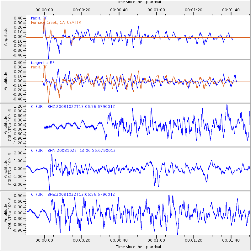
Signal To Noise
| Channel | StoN | STA | LTA |
| CI:FUR: :BHN:20081022T13:06:56.679001Z | 4.848488 | 9.927579E-7 | 2.0475618E-7 |
| CI:FUR: :BHE:20081022T13:06:56.679001Z | 1.5580109 | 3.4029557E-7 | 2.1841667E-7 |
| CI:FUR: :BHZ:20081022T13:06:56.679001Z | 3.2738597 | 4.154515E-7 | 1.268996E-7 |
| Arrivals |
| Ps | |
| PpPs | |
| PsPs/PpSs | |


