You are here: Home > Network List > AV - Alaska Volcano Observatory Stations List
> Station AKRB Akutan Reef Bight, Akutan Volcano, Alaska > Earthquake Result Viewer
AKRB Akutan Reef Bight, Akutan Volcano, Alaska - Earthquake Result Viewer
| Earthquake location: |
Solomon Islands |
| Earthquake latitude/longitude: |
-10.7/161.3 |
| Earthquake time(UTC): |
2016/12/08 (343) 17:38:46 GMT |
| Earthquake Depth: |
41 km |
| Earthquake Magnitude: |
7.8 mww |
| Earthquake Catalog/Contributor: |
NEIC PDE/us |
|
| Network: |
AV Alaska Volcano Observatory |
| Station: |
AKRB Akutan Reef Bight, Akutan Volcano, Alaska |
| Lat/Lon: |
54.13 N/166.07 W |
| Elevation: |
334 m |
|
| Distance: |
70.2 deg |
| Az: |
19.693 deg |
| Baz: |
214.249 deg |
| Ray Param: |
0.055060472 |
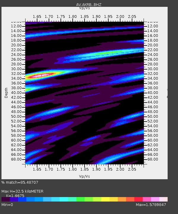
| Estimated Moho Depth: |
32.5 km |
| Estimated Crust Vp/Vs: |
1.67 |
| Assumed Crust Vp: |
5.989 km/s |
| Estimated Crust Vs: |
3.592 km/s |
| Estimated Crust Poisson's Ratio: |
0.22 |
|
| Radial Match: |
85.48707 % |
| Radial Bump: |
400 |
| Transverse Match: |
71.72886 % |
| Transverse Bump: |
400 |
| SOD ConfigId: |
11737051 |
| Insert Time: |
2019-04-26 05:59:09.036 +0000 |
| GWidth: |
2.5 |
| Max Bumps: |
400 |
| Tol: |
0.001 |
|

Signal To Noise
| Channel | StoN | STA | LTA |
| AV:AKRB: :BHZ:20161208T17:49:24.179011Z | 3.1451056 | 6.5849604E-6 | 2.0937166E-6 |
| AV:AKRB: :BHN:20161208T17:49:24.179011Z | 0.66373014 | 2.2449626E-6 | 3.3823424E-6 |
| AV:AKRB: :BHE:20161208T17:49:24.179011Z | 0.91985923 | 2.779908E-6 | 3.0221017E-6 |
| Arrivals |
| Ps | 3.7 SECOND |
| PpPs | 14 SECOND |
| PsPs/PpSs | 18 SECOND |


