You are here: Home > Network List > AZ - ANZA Regional Network Stations List
> Station TRO AZ.TRO > Earthquake Result Viewer
TRO AZ.TRO - Earthquake Result Viewer
| Earthquake location: |
Solomon Islands |
| Earthquake latitude/longitude: |
-10.7/161.3 |
| Earthquake time(UTC): |
2016/12/08 (343) 17:38:46 GMT |
| Earthquake Depth: |
41 km |
| Earthquake Magnitude: |
7.8 mww |
| Earthquake Catalog/Contributor: |
NEIC PDE/us |
|
| Network: |
AZ ANZA Regional Network |
| Station: |
TRO AZ.TRO |
| Lat/Lon: |
33.52 N/116.43 W |
| Elevation: |
2628 m |
|
| Distance: |
89.4 deg |
| Az: |
55.869 deg |
| Baz: |
256.898 deg |
| Ray Param: |
0.04178381 |
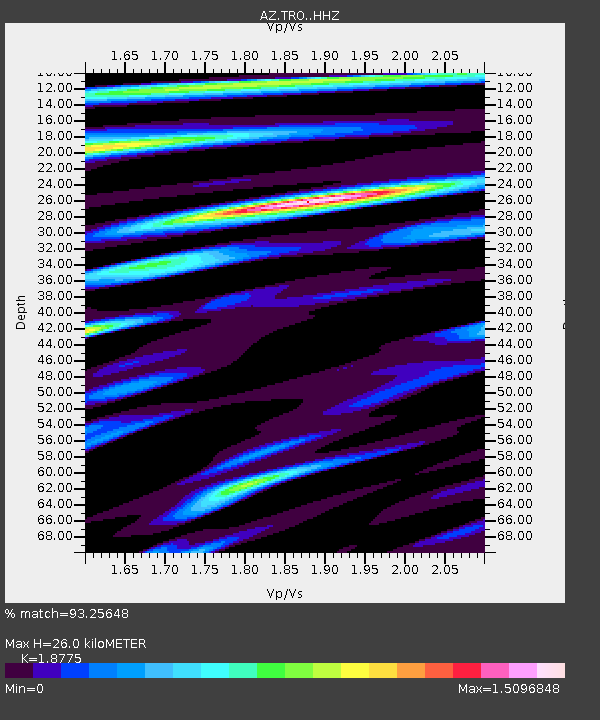
| Estimated Moho Depth: |
26.0 km |
| Estimated Crust Vp/Vs: |
1.88 |
| Assumed Crust Vp: |
6.264 km/s |
| Estimated Crust Vs: |
3.336 km/s |
| Estimated Crust Poisson's Ratio: |
0.30 |
|
| Radial Match: |
93.25648 % |
| Radial Bump: |
400 |
| Transverse Match: |
88.2344 % |
| Transverse Bump: |
400 |
| SOD ConfigId: |
11737051 |
| Insert Time: |
2019-04-26 05:59:42.051 +0000 |
| GWidth: |
2.5 |
| Max Bumps: |
400 |
| Tol: |
0.001 |
|

Signal To Noise
| Channel | StoN | STA | LTA |
| AZ:TRO: :HHZ:20161208T17:51:07.757991Z | 22.376743 | 7.821969E-6 | 3.4955798E-7 |
| AZ:TRO: :HHN:20161208T17:51:07.757991Z | 1.960119 | 6.1058176E-7 | 3.1150236E-7 |
| AZ:TRO: :HHE:20161208T17:51:07.757991Z | 4.027279 | 2.3351756E-6 | 5.798396E-7 |
| Arrivals |
| Ps | 3.7 SECOND |
| PpPs | 12 SECOND |
| PsPs/PpSs | 15 SECOND |


