You are here: Home > Network List > CB - China National Seismic Network Stations List
> Station TIA Taian,Shandong Province > Earthquake Result Viewer
TIA Taian,Shandong Province - Earthquake Result Viewer
| Earthquake location: |
Solomon Islands |
| Earthquake latitude/longitude: |
-10.7/161.3 |
| Earthquake time(UTC): |
2016/12/08 (343) 17:38:46 GMT |
| Earthquake Depth: |
41 km |
| Earthquake Magnitude: |
7.8 mww |
| Earthquake Catalog/Contributor: |
NEIC PDE/us |
|
| Network: |
CB China National Seismic Network |
| Station: |
TIA Taian,Shandong Province |
| Lat/Lon: |
36.21 N/117.12 E |
| Elevation: |
267 m |
|
| Distance: |
62.5 deg |
| Az: |
320.532 deg |
| Baz: |
129.417 deg |
| Ray Param: |
0.060098547 |
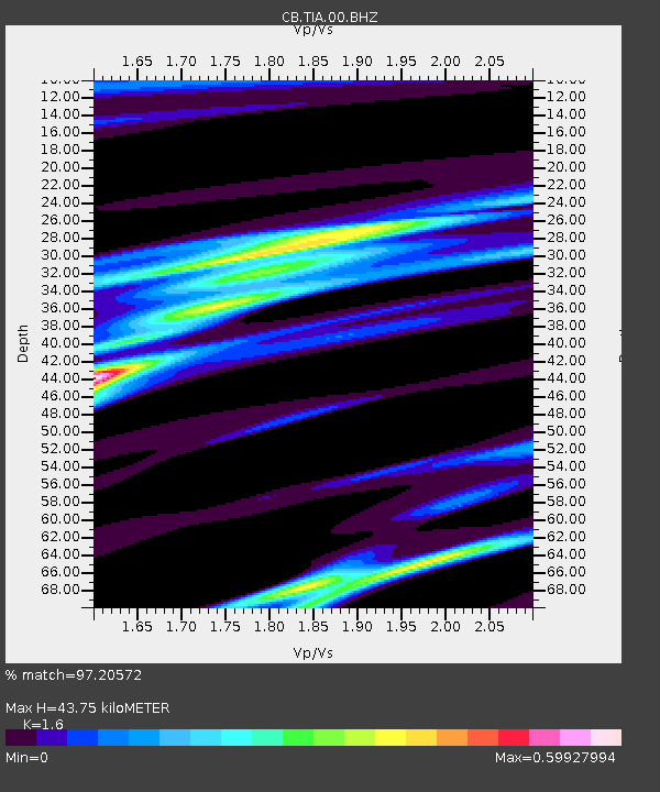
| Estimated Moho Depth: |
43.75 km |
| Estimated Crust Vp/Vs: |
1.60 |
| Assumed Crust Vp: |
6.363 km/s |
| Estimated Crust Vs: |
3.977 km/s |
| Estimated Crust Poisson's Ratio: |
0.18 |
|
| Radial Match: |
97.20572 % |
| Radial Bump: |
201 |
| Transverse Match: |
78.394424 % |
| Transverse Bump: |
400 |
| SOD ConfigId: |
11737051 |
| Insert Time: |
2019-04-26 06:00:20.601 +0000 |
| GWidth: |
2.5 |
| Max Bumps: |
400 |
| Tol: |
0.001 |
|

Signal To Noise
| Channel | StoN | STA | LTA |
| CB:TIA:00:BHZ:20161208T17:48:35.049983Z | 22.799568 | 6.8845966E-6 | 3.019617E-7 |
| CB:TIA:00:BHN:20161208T17:48:35.049983Z | 13.489514 | 2.3467128E-6 | 1.7396569E-7 |
| CB:TIA:00:BHE:20161208T17:48:35.049983Z | 11.101659 | 2.6174998E-6 | 2.3577557E-7 |
| Arrivals |
| Ps | 4.3 SECOND |
| PpPs | 17 SECOND |
| PsPs/PpSs | 21 SECOND |


