You are here: Home > Network List > CB - China National Seismic Network Stations List
> Station XLT Xilinhaote,Neimeng Province > Earthquake Result Viewer
XLT Xilinhaote,Neimeng Province - Earthquake Result Viewer
| Earthquake location: |
Solomon Islands |
| Earthquake latitude/longitude: |
-10.7/161.3 |
| Earthquake time(UTC): |
2016/12/08 (343) 17:38:46 GMT |
| Earthquake Depth: |
41 km |
| Earthquake Magnitude: |
7.8 mww |
| Earthquake Catalog/Contributor: |
NEIC PDE/us |
|
| Network: |
CB China National Seismic Network |
| Station: |
XLT Xilinhaote,Neimeng Province |
| Lat/Lon: |
43.90 N/116.08 E |
| Elevation: |
1030 m |
|
| Distance: |
68.1 deg |
| Az: |
326.405 deg |
| Baz: |
131.204 deg |
| Ray Param: |
0.056452915 |
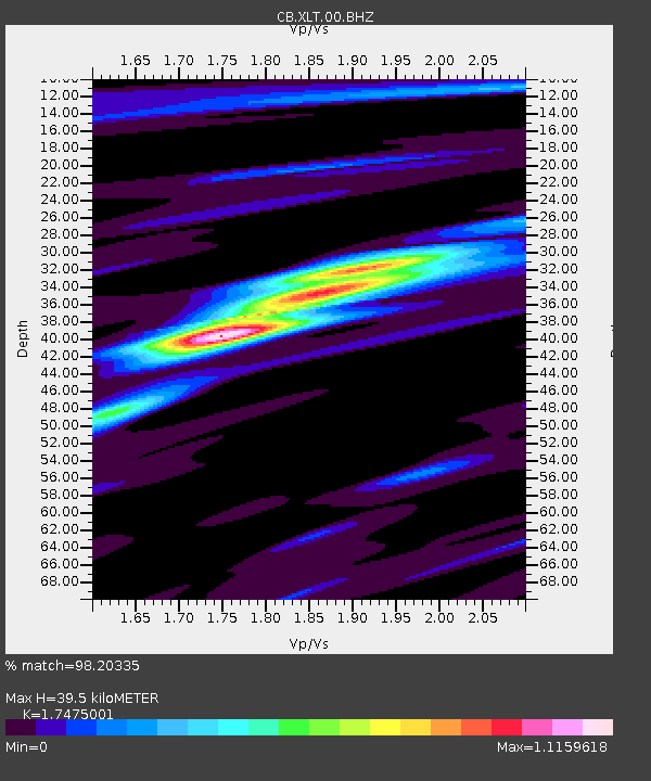
| Estimated Moho Depth: |
39.5 km |
| Estimated Crust Vp/Vs: |
1.75 |
| Assumed Crust Vp: |
6.459 km/s |
| Estimated Crust Vs: |
3.696 km/s |
| Estimated Crust Poisson's Ratio: |
0.26 |
|
| Radial Match: |
98.20335 % |
| Radial Bump: |
231 |
| Transverse Match: |
92.574715 % |
| Transverse Bump: |
400 |
| SOD ConfigId: |
11737051 |
| Insert Time: |
2019-04-26 06:00:22.294 +0000 |
| GWidth: |
2.5 |
| Max Bumps: |
400 |
| Tol: |
0.001 |
|

Signal To Noise
| Channel | StoN | STA | LTA |
| CB:XLT:00:BHZ:20161208T17:49:11.11999Z | 42.648033 | 9.246488E-6 | 2.1680924E-7 |
| CB:XLT:00:BHN:20161208T17:49:11.11999Z | 21.447617 | 2.6759799E-6 | 1.2476818E-7 |
| CB:XLT:00:BHE:20161208T17:49:11.11999Z | 25.028194 | 3.217209E-6 | 1.2854339E-7 |
| Arrivals |
| Ps | 4.8 SECOND |
| PpPs | 16 SECOND |
| PsPs/PpSs | 21 SECOND |


