You are here: Home > Network List > CI - Caltech Regional Seismic Network Stations List
> Station GLA Glamis, Glamis, CA, USA > Earthquake Result Viewer
GLA Glamis, Glamis, CA, USA - Earthquake Result Viewer

| Earthquake location: |
Solomon Islands |
| Earthquake latitude/longitude: |
-10.7/161.3 |
| Earthquake time(UTC): |
2016/12/08 (343) 17:38:46 GMT |
| Earthquake Depth: |
41 km |
| Earthquake Magnitude: |
7.8 mww |
| Earthquake Catalog/Contributor: |
NEIC PDE/us |
|
| Network: |
CI Caltech Regional Seismic Network |
| Station: |
GLA Glamis, Glamis, CA, USA |
| Lat/Lon: |
33.05 N/114.83 W |
| Elevation: |
610 m |
|
| Distance: |
90.7 deg |
| Az: |
56.622 deg |
| Baz: |
257.771 deg |
| Ray Param: |
0.04165241 |
| Estimated Moho Depth: |
26.25 km |
| Estimated Crust Vp/Vs: |
1.63 |
| Assumed Crust Vp: |
6.155 km/s |
| Estimated Crust Vs: |
3.77 km/s |
| Estimated Crust Poisson's Ratio: |
0.20 |
|
| Radial Match: |
96.72158 % |
| Radial Bump: |
377 |
| Transverse Match: |
84.00514 % |
| Transverse Bump: |
400 |
| SOD ConfigId: |
11737051 |
| Insert Time: |
2019-04-26 06:00:41.199 +0000 |
| GWidth: |
2.5 |
| Max Bumps: |
400 |
| Tol: |
0.001 |
|
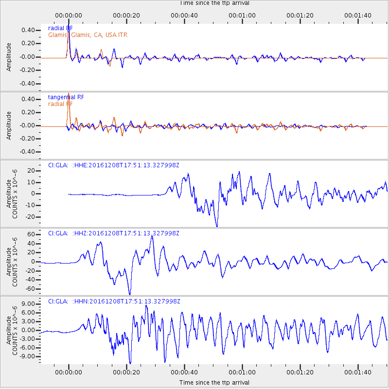
Signal To Noise
| Channel | StoN | STA | LTA |
| CI:GLA: :HHZ:20161208T17:51:13.327998Z | 11.321423 | 6.7790806E-6 | 5.9878346E-7 |
| CI:GLA: :HHN:20161208T17:51:13.327998Z | 4.174204 | 8.4950693E-7 | 2.0351354E-7 |
| CI:GLA: :HHE:20161208T17:51:13.327998Z | 5.8387203 | 2.1334993E-6 | 3.6540527E-7 |
| Arrivals |
| Ps | 2.8 SECOND |
| PpPs | 11 SECOND |
| PsPs/PpSs | 14 SECOND |


