You are here: Home > Network List > CI - Caltech Regional Seismic Network Stations List
> Station MPM Manuel Prospect Mine, California, USA > Earthquake Result Viewer
MPM Manuel Prospect Mine, California, USA - Earthquake Result Viewer
| Earthquake location: |
Vanuatu Islands Region |
| Earthquake latitude/longitude: |
-20.9/173.8 |
| Earthquake time(UTC): |
2005/08/09 (221) 05:26:17 GMT |
| Earthquake Depth: |
24 km |
| Earthquake Magnitude: |
5.5 MB, 6.0 MS, 6.1 MW, 6.1 MW |
| Earthquake Catalog/Contributor: |
WHDF/NEIC |
|
| Network: |
CI Caltech Regional Seismic Network |
| Station: |
MPM Manuel Prospect Mine, California, USA |
| Lat/Lon: |
36.06 N/117.49 W |
| Elevation: |
185 m |
|
| Distance: |
86.2 deg |
| Az: |
49.163 deg |
| Baz: |
240.782 deg |
| Ray Param: |
0.044229466 |
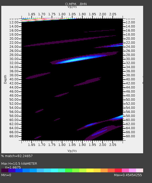
| Estimated Moho Depth: |
10.5 km |
| Estimated Crust Vp/Vs: |
1.67 |
| Assumed Crust Vp: |
6.279 km/s |
| Estimated Crust Vs: |
3.765 km/s |
| Estimated Crust Poisson's Ratio: |
0.22 |
|
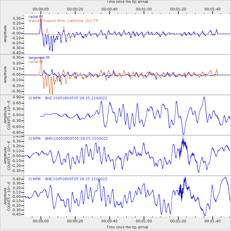
| Radial Match: |
92.24657 % |
| Radial Bump: |
400 |
| Transverse Match: |
69.33541 % |
| Transverse Bump: |
392 |
| SOD ConfigId: |
2422 |
| Insert Time: |
2010-03-05 20:18:29.090 +0000 |
| GWidth: |
2.5 |
| Max Bumps: |
400 |
| Tol: |
0.001 |
|
Signal To Noise
| Channel | StoN | STA | LTA |
| CI:MPM: :BHN:20050809T05:38:25.220002Z | 1.2592615 | 6.8469184E-8 | 5.437249E-8 |
| CI:MPM: :BHE:20050809T05:38:25.220002Z | 3.6476252 | 1.2896906E-7 | 3.5356994E-8 |
| CI:MPM: :BHZ:20050809T05:38:25.220002Z | 2.3427856 | 1.980159E-7 | 8.452157E-8 |
| Arrivals |
| Ps | 1.1 SECOND |
| PpPs | 4.4 SECOND |
| PsPs/PpSs | 5.5 SECOND |


