You are here: Home > Network List > CN - Canadian National Seismograph Network Stations List
> Station GRNB Grenville Island, BC, CA > Earthquake Result Viewer
GRNB Grenville Island, BC, CA - Earthquake Result Viewer
| Earthquake location: |
Solomon Islands |
| Earthquake latitude/longitude: |
-10.7/161.3 |
| Earthquake time(UTC): |
2016/12/08 (343) 17:38:46 GMT |
| Earthquake Depth: |
41 km |
| Earthquake Magnitude: |
7.8 mww |
| Earthquake Catalog/Contributor: |
NEIC PDE/us |
|
| Network: |
CN Canadian National Seismograph Network |
| Station: |
GRNB Grenville Island, BC, CA |
| Lat/Lon: |
53.85 N/129.96 W |
| Elevation: |
461 m |
|
| Distance: |
86.4 deg |
| Az: |
33.587 deg |
| Baz: |
246.59 deg |
| Ray Param: |
0.0440341 |
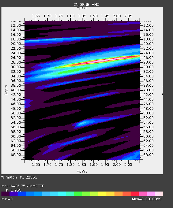
| Estimated Moho Depth: |
26.75 km |
| Estimated Crust Vp/Vs: |
1.96 |
| Assumed Crust Vp: |
6.545 km/s |
| Estimated Crust Vs: |
3.348 km/s |
| Estimated Crust Poisson's Ratio: |
0.32 |
|
| Radial Match: |
91.22553 % |
| Radial Bump: |
345 |
| Transverse Match: |
76.6588 % |
| Transverse Bump: |
400 |
| SOD ConfigId: |
11737051 |
| Insert Time: |
2019-04-26 06:01:22.974 +0000 |
| GWidth: |
2.5 |
| Max Bumps: |
400 |
| Tol: |
0.001 |
|

Signal To Noise
| Channel | StoN | STA | LTA |
| CN:GRNB: :HHZ:20161208T17:50:53.127986Z | 16.46095 | 7.8883495E-6 | 4.7921594E-7 |
| CN:GRNB: :HHN:20161208T17:50:53.127986Z | 2.5646365 | 1.1245153E-6 | 4.3846964E-7 |
| CN:GRNB: :HHE:20161208T17:50:53.127986Z | 6.8947268 | 2.420547E-6 | 3.510722E-7 |
| Arrivals |
| Ps | 4.0 SECOND |
| PpPs | 12 SECOND |
| PsPs/PpSs | 16 SECOND |


