You are here: Home > Network List > GE - GEOFON Stations List
> Station SNAA GEOFON/AWI Station Sanae, Antarctica > Earthquake Result Viewer
SNAA GEOFON/AWI Station Sanae, Antarctica - Earthquake Result Viewer
| Earthquake location: |
Solomon Islands |
| Earthquake latitude/longitude: |
-10.7/161.3 |
| Earthquake time(UTC): |
2016/12/08 (343) 17:38:46 GMT |
| Earthquake Depth: |
41 km |
| Earthquake Magnitude: |
7.8 mww |
| Earthquake Catalog/Contributor: |
NEIC PDE/us |
|
| Network: |
GE GEOFON |
| Station: |
SNAA GEOFON/AWI Station Sanae, Antarctica |
| Lat/Lon: |
71.67 S/2.84 W |
| Elevation: |
846 m |
|
| Distance: |
97.2 deg |
| Az: |
184.991 deg |
| Baz: |
164.32 deg |
| Ray Param: |
0.040275794 |
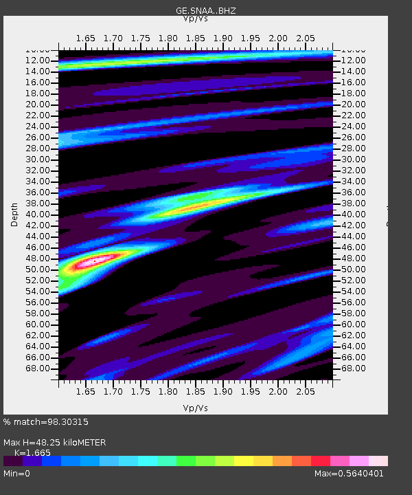
| Estimated Moho Depth: |
48.25 km |
| Estimated Crust Vp/Vs: |
1.66 |
| Assumed Crust Vp: |
6.43 km/s |
| Estimated Crust Vs: |
3.862 km/s |
| Estimated Crust Poisson's Ratio: |
0.22 |
|
| Radial Match: |
98.30315 % |
| Radial Bump: |
362 |
| Transverse Match: |
80.50884 % |
| Transverse Bump: |
400 |
| SOD ConfigId: |
11737051 |
| Insert Time: |
2019-04-26 06:01:51.758 +0000 |
| GWidth: |
2.5 |
| Max Bumps: |
400 |
| Tol: |
0.001 |
|

Signal To Noise
| Channel | StoN | STA | LTA |
| GE:SNAA: :BHZ:20161208T17:51:43.010981Z | 35.0597 | 4.9445656E-4 | 1.4103274E-5 |
| GE:SNAA: :BHN:20161208T17:51:43.010981Z | 24.294645 | 1.7441595E-4 | 7.1791933E-6 |
| GE:SNAA: :BHE:20161208T17:51:43.010981Z | 7.388719 | 4.1031337E-5 | 5.553241E-6 |
| Arrivals |
| Ps | 5.1 SECOND |
| PpPs | 20 SECOND |
| PsPs/PpSs | 25 SECOND |


