You are here: Home > Network List > HV - Hawaiian Volcano Observatory Network Stations List
> Station HAT Halemaumau Trail > Earthquake Result Viewer
HAT Halemaumau Trail - Earthquake Result Viewer
| Earthquake location: |
Solomon Islands |
| Earthquake latitude/longitude: |
-10.7/161.3 |
| Earthquake time(UTC): |
2016/12/08 (343) 17:38:46 GMT |
| Earthquake Depth: |
41 km |
| Earthquake Magnitude: |
7.8 mww |
| Earthquake Catalog/Contributor: |
NEIC PDE/us |
|
| Network: |
HV Hawaiian Volcano Observatory Network |
| Station: |
HAT Halemaumau Trail |
| Lat/Lon: |
19.42 N/155.26 W |
| Elevation: |
1097 m |
|
| Distance: |
52.2 deg |
| Az: |
55.18 deg |
| Baz: |
238.758 deg |
| Ray Param: |
0.066830665 |
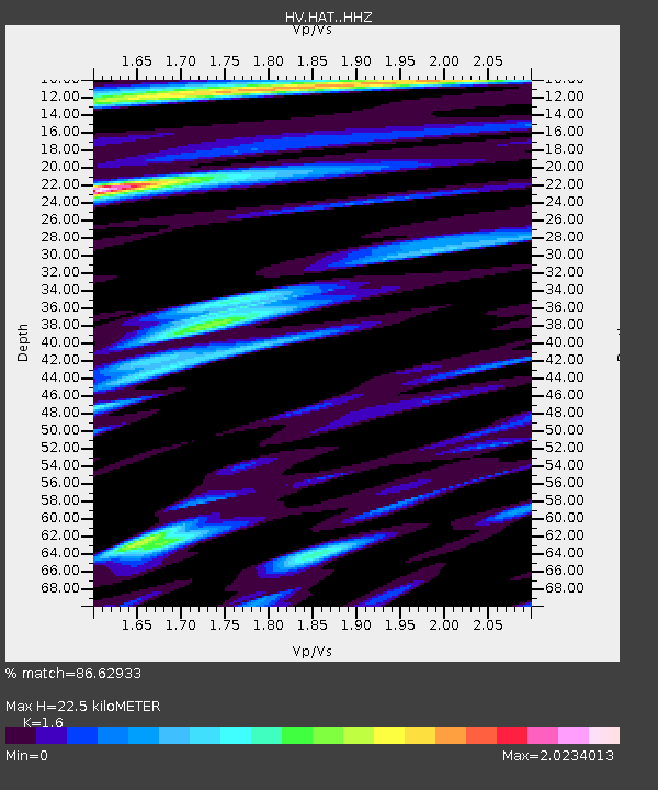
| Estimated Moho Depth: |
22.5 km |
| Estimated Crust Vp/Vs: |
1.60 |
| Assumed Crust Vp: |
5.195 km/s |
| Estimated Crust Vs: |
3.247 km/s |
| Estimated Crust Poisson's Ratio: |
0.18 |
|
| Radial Match: |
86.62933 % |
| Radial Bump: |
400 |
| Transverse Match: |
70.374535 % |
| Transverse Bump: |
400 |
| SOD ConfigId: |
11737051 |
| Insert Time: |
2019-04-26 06:01:54.535 +0000 |
| GWidth: |
2.5 |
| Max Bumps: |
400 |
| Tol: |
0.001 |
|

Signal To Noise
| Channel | StoN | STA | LTA |
| HV:HAT: :HHZ:20161208T17:47:22.429988Z | 6.516703 | 1.260789E-5 | 1.9347037E-6 |
| HV:HAT: :HHN:20161208T17:47:22.429988Z | 1.4535159 | 5.360346E-6 | 3.6878484E-6 |
| HV:HAT: :HHE:20161208T17:47:22.429988Z | 2.3140478 | 8.6806385E-6 | 3.7512787E-6 |
| Arrivals |
| Ps | 2.7 SECOND |
| PpPs | 11 SECOND |
| PsPs/PpSs | 14 SECOND |


