You are here: Home > Network List > CI - Caltech Regional Seismic Network Stations List
> Station SDD SDD, Mission Viejo, CA, USA > Earthquake Result Viewer
SDD SDD, Mission Viejo, CA, USA - Earthquake Result Viewer
| Earthquake location: |
Near Coast Of Peru |
| Earthquake latitude/longitude: |
-17.5/-72.1 |
| Earthquake time(UTC): |
2001/07/07 (188) 09:38:43 GMT |
| Earthquake Depth: |
33 km |
| Earthquake Magnitude: |
6.6 MB, 7.3 MS, 7.6 MW, 7.5 ME |
| Earthquake Catalog/Contributor: |
WHDF/NEIC |
|
| Network: |
CI Caltech Regional Seismic Network |
| Station: |
SDD SDD, Mission Viejo, CA, USA |
| Lat/Lon: |
33.55 N/117.66 W |
| Elevation: |
120 m |
|
| Distance: |
66.9 deg |
| Az: |
319.563 deg |
| Baz: |
132.18 deg |
| Ray Param: |
0.057274926 |
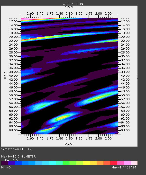
| Estimated Moho Depth: |
10.0 km |
| Estimated Crust Vp/Vs: |
1.72 |
| Assumed Crust Vp: |
6.264 km/s |
| Estimated Crust Vs: |
3.652 km/s |
| Estimated Crust Poisson's Ratio: |
0.24 |
|
| Radial Match: |
93.163475 % |
| Radial Bump: |
400 |
| Transverse Match: |
87.85605 % |
| Transverse Bump: |
400 |
| SOD ConfigId: |
3770 |
| Insert Time: |
2010-02-26 00:55:13.969 +0000 |
| GWidth: |
2.5 |
| Max Bumps: |
400 |
| Tol: |
0.001 |
|

Signal To Noise
| Channel | StoN | STA | LTA |
| CI:SDD: :BHN:20010707T09:49:01.434001Z | 0.88972455 | 4.4929132E-7 | 5.04978E-7 |
| CI:SDD: :BHE:20010707T09:49:01.434001Z | 1.1195334 | 6.301433E-7 | 5.628624E-7 |
| CI:SDD: :BHZ:20010707T09:49:01.434001Z | 1.4527433 | 5.442917E-7 | 3.7466475E-7 |
| Arrivals |
| Ps | 1.2 SECOND |
| PpPs | 4.2 SECOND |
| PsPs/PpSs | 5.4 SECOND |


