You are here: Home > Network List > HV - Hawaiian Volcano Observatory Network Stations List
> Station OBL Observatory Bluff > Earthquake Result Viewer
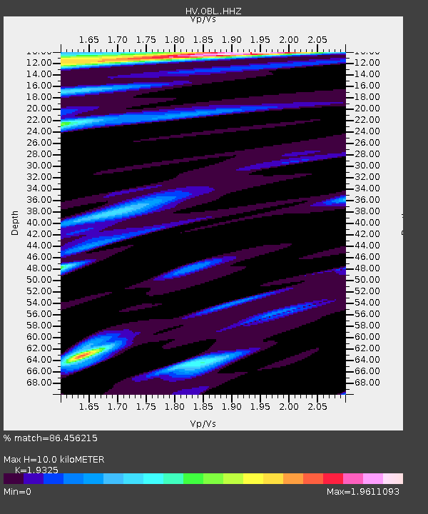
OBL Observatory Bluff - Earthquake Result Viewer
| Earthquake location: |
Solomon Islands |
| Earthquake latitude/longitude: |
-10.7/161.3 |
| Earthquake time(UTC): |
2016/12/08 (343) 17:38:46 GMT |
| Earthquake Depth: |
41 km |
| Earthquake Magnitude: |
7.8 mww |
| Earthquake Catalog/Contributor: |
NEIC PDE/us |
|
| Network: |
HV Hawaiian Volcano Observatory Network |
| Station: |
OBL Observatory Bluff |
| Lat/Lon: |
19.42 N/155.28 W |
| Elevation: |
1119 m |
|
| Distance: |
52.2 deg |
| Az: |
55.172 deg |
| Baz: |
238.745 deg |
| Ray Param: |
0.066844374 |
| Estimated Moho Depth: |
10.0 km |
| Estimated Crust Vp/Vs: |
1.93 |
| Assumed Crust Vp: |
5.195 km/s |
| Estimated Crust Vs: |
2.688 km/s |
| Estimated Crust Poisson's Ratio: |
0.32 |
|
| Radial Match: |
86.456215 % |
| Radial Bump: |
400 |
| Transverse Match: |
73.05335 % |
| Transverse Bump: |
400 |
| SOD ConfigId: |
11737051 |
| Insert Time: |
2019-04-26 06:02:05.027 +0000 |
| GWidth: |
2.5 |
| Max Bumps: |
400 |
| Tol: |
0.001 |
|

Signal To Noise
| Channel | StoN | STA | LTA |
| HV:OBL: :HHZ:20161208T17:47:22.27502Z | 3.940994 | 1.295958E-5 | 3.2884038E-6 |
| HV:OBL: :HHN:20161208T17:47:22.27502Z | 0.902751 | 5.6525237E-6 | 6.261442E-6 |
| HV:OBL: :HHE:20161208T17:47:22.27502Z | 1.6260749 | 9.095141E-6 | 5.5933097E-6 |
| Arrivals |
| Ps | 1.9 SECOND |
| PpPs | 5.5 SECOND |
| PsPs/PpSs | 7.3 SECOND |


