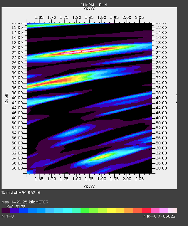
MPM Manuel Prospect Mine, California, USA - Earthquake Result Viewer
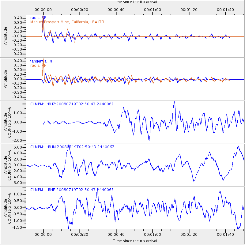
Earthquake location: Off East Coast Of Honshu, Japan
Earthquake latitude/longitude: 37.6/142.2
Earthquake time(UTC): 2008/07/19 (201) 02:39:28 GMT
Earthquake Depth: 22 km
Earthquake Magnitude: 6.2 MB, 7.0 MS, 7.0 MW, 6.9 MW
Earthquake Catalog/Contributor: WHDF/NEIC
Network: CI Caltech Regional Seismic Network
Station: MPM Manuel Prospect Mine, California, USA
Lat/Lon: 36.06 N/117.49 W
Elevation: 185 m
Distance: 76.1 deg
Az: 55.221 deg
Baz: 306.329 deg
Ray Param: 0.051210962
Estimated Moho Depth: 21.25 km
Estimated Crust Vp/Vs: 1.82
Assumed Crust Vp: 6.279 km/s
Estimated Crust Vs: 3.455 km/s
Estimated Crust Poisson's Ratio: 0.28
Radial Match: 90.95246 %
Radial Bump: 400
Transverse Match: 77.76293 %
Transverse Bump: 400
SOD ConfigId: 2504
Insert Time: 2010-03-05 20:18:50.262 +0000
GWidth: 2.5
Max Bumps: 400
Tol: 0.001

Signal To Noise

ChannelStoNSTALTA
CI:MPM: :BHN:20080719T02:50:43.244006Z2.84205964.4351287E-71.5605333E-7
CI:MPM: :BHE:20080719T02:50:43.244006Z0.95278631.0422457E-71.09389234E-7
CI:MPM: :BHZ:20080719T02:50:43.244006Z1.49329541.4416008E-79.653822E-8
Arrivals
Ps2.8 SECOND
PpPs9.3 SECOND
PsPs/PpSs12 SECOND