You are here: Home > Network List > IW - Intermountain West Stations List
> Station DLMT Dillon, Montana, USA > Earthquake Result Viewer
DLMT Dillon, Montana, USA - Earthquake Result Viewer
| Earthquake location: |
Vanuatu Islands |
| Earthquake latitude/longitude: |
-14.8/167.3 |
| Earthquake time(UTC): |
2015/10/20 (293) 21:52:02 GMT |
| Earthquake Depth: |
127 km |
| Earthquake Magnitude: |
7.1 MWW, 7.3 MI |
| Earthquake Catalog/Contributor: |
NEIC PDE/NEIC COMCAT |
|
| Network: |
IW Intermountain West |
| Station: |
DLMT Dillon, Montana, USA |
| Lat/Lon: |
45.36 N/112.60 W |
| Elevation: |
1569 m |
|
| Distance: |
93.6 deg |
| Az: |
44.099 deg |
| Baz: |
252.663 deg |
| Ray Param: |
0.04114829 |
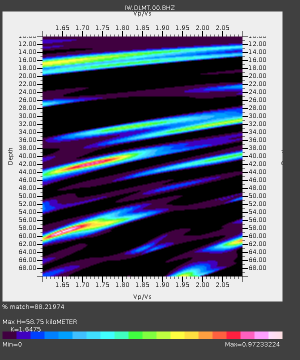
| Estimated Moho Depth: |
58.75 km |
| Estimated Crust Vp/Vs: |
1.65 |
| Assumed Crust Vp: |
6.577 km/s |
| Estimated Crust Vs: |
3.992 km/s |
| Estimated Crust Poisson's Ratio: |
0.21 |
|
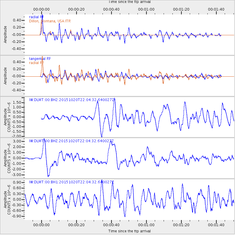
| Radial Match: |
88.21974 % |
| Radial Bump: |
400 |
| Transverse Match: |
80.13278 % |
| Transverse Bump: |
400 |
| SOD ConfigId: |
1259291 |
| Insert Time: |
2015-11-03 22:21:01.715 +0000 |
| GWidth: |
2.5 |
| Max Bumps: |
400 |
| Tol: |
0.001 |
|
Signal To Noise
| Channel | StoN | STA | LTA |
| IW:DLMT:00:BHZ:20151020T22:04:32.640027Z | 27.06967 | 2.193935E-6 | 8.1047716E-8 |
| IW:DLMT:00:BH1:20151020T22:04:32.640027Z | 1.433783 | 2.4297273E-7 | 1.6946268E-7 |
| IW:DLMT:00:BH2:20151020T22:04:32.640027Z | 7.398627 | 1.1175175E-6 | 1.5104392E-7 |
| Arrivals |
| Ps | 5.9 SECOND |
| PpPs | 23 SECOND |
| PsPs/PpSs | 29 SECOND |


