You are here: Home > Network List > CI - Caltech Regional Seismic Network Stations List
> Station SDD SDD, Mission Viejo, CA, USA > Earthquake Result Viewer
SDD SDD, Mission Viejo, CA, USA - Earthquake Result Viewer
| Earthquake location: |
Near Coast Of Peru |
| Earthquake latitude/longitude: |
-17.8/-71.3 |
| Earthquake time(UTC): |
2001/06/23 (174) 21:05:39 GMT |
| Earthquake Depth: |
33 km |
| Earthquake Magnitude: |
5.8 MB |
| Earthquake Catalog/Contributor: |
WHDF/NEIC |
|
| Network: |
CI Caltech Regional Seismic Network |
| Station: |
SDD SDD, Mission Viejo, CA, USA |
| Lat/Lon: |
33.55 N/117.66 W |
| Elevation: |
120 m |
|
| Distance: |
67.5 deg |
| Az: |
319.202 deg |
| Baz: |
131.817 deg |
| Ray Param: |
0.05683304 |
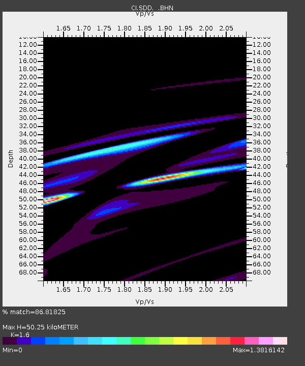
| Estimated Moho Depth: |
50.25 km |
| Estimated Crust Vp/Vs: |
1.60 |
| Assumed Crust Vp: |
6.264 km/s |
| Estimated Crust Vs: |
3.915 km/s |
| Estimated Crust Poisson's Ratio: |
0.18 |
|
| Radial Match: |
86.81825 % |
| Radial Bump: |
400 |
| Transverse Match: |
82.16235 % |
| Transverse Bump: |
245 |
| SOD ConfigId: |
3770 |
| Insert Time: |
2010-02-26 00:55:15.801 +0000 |
| GWidth: |
2.5 |
| Max Bumps: |
400 |
| Tol: |
0.001 |
|
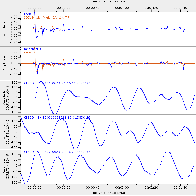
Signal To Noise
| Channel | StoN | STA | LTA |
| CI:SDD: :BHN:20010623T21:16:01.383013Z | 0.20185132 | 2.4491166E-5 | 1.21332705E-4 |
| CI:SDD: :BHE:20010623T21:16:01.383013Z | 1.2421966 | 1.1197082E-4 | 9.0139365E-5 |
| CI:SDD: :BHZ:20010623T21:16:01.383013Z | 0.031183684 | 3.2866947E-6 | 1.0539789E-4 |
| Arrivals |
| Ps | 5.0 SECOND |
| PpPs | 20 SECOND |
| PsPs/PpSs | 25 SECOND |


