You are here: Home > Network List > MM - Myanmar National Seismic Network Stations List
> Station TMU Tamu, Sagaing, Myanmar > Earthquake Result Viewer
TMU Tamu, Sagaing, Myanmar - Earthquake Result Viewer
| Earthquake location: |
Solomon Islands |
| Earthquake latitude/longitude: |
-10.7/161.3 |
| Earthquake time(UTC): |
2016/12/08 (343) 17:38:46 GMT |
| Earthquake Depth: |
41 km |
| Earthquake Magnitude: |
7.8 mww |
| Earthquake Catalog/Contributor: |
NEIC PDE/us |
|
| Network: |
MM Myanmar National Seismic Network |
| Station: |
TMU Tamu, Sagaing, Myanmar |
| Lat/Lon: |
24.23 N/94.30 E |
| Elevation: |
182 m |
|
| Distance: |
74.0 deg |
| Az: |
299.041 deg |
| Baz: |
109.731 deg |
| Ray Param: |
0.05253572 |
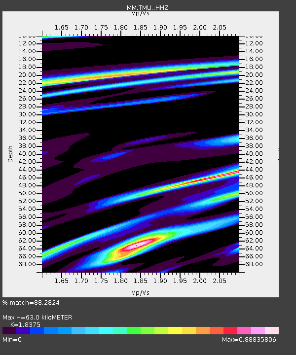
| Estimated Moho Depth: |
63.0 km |
| Estimated Crust Vp/Vs: |
1.84 |
| Assumed Crust Vp: |
6.316 km/s |
| Estimated Crust Vs: |
3.437 km/s |
| Estimated Crust Poisson's Ratio: |
0.29 |
|
| Radial Match: |
88.2824 % |
| Radial Bump: |
400 |
| Transverse Match: |
84.48877 % |
| Transverse Bump: |
400 |
| SOD ConfigId: |
11737051 |
| Insert Time: |
2019-04-26 06:02:57.849 +0000 |
| GWidth: |
2.5 |
| Max Bumps: |
400 |
| Tol: |
0.001 |
|

Signal To Noise
| Channel | StoN | STA | LTA |
| MM:TMU: :HHZ:20161208T17:49:46.958003Z | 42.687332 | 8.946481E-6 | 2.0958163E-7 |
| MM:TMU: :HHN:20161208T17:49:46.958003Z | 41.223175 | 1.8238524E-6 | 4.4243375E-8 |
| MM:TMU: :HHE:20161208T17:49:46.958003Z | 45.56279 | 2.99473E-6 | 6.572754E-8 |
| Arrivals |
| Ps | 8.6 SECOND |
| PpPs | 27 SECOND |
| PsPs/PpSs | 36 SECOND |


