You are here: Home > Network List > NN - Western Great Basin/Eastern Sierra Nevada Stations List
> Station LCH Last Chance Range, CA. (GPS 01/04/2001) w84 > Earthquake Result Viewer
LCH Last Chance Range, CA. (GPS 01/04/2001) w84 - Earthquake Result Viewer
| Earthquake location: |
Solomon Islands |
| Earthquake latitude/longitude: |
-10.7/161.3 |
| Earthquake time(UTC): |
2016/12/08 (343) 17:38:46 GMT |
| Earthquake Depth: |
41 km |
| Earthquake Magnitude: |
7.8 mww |
| Earthquake Catalog/Contributor: |
NEIC PDE/us |
|
| Network: |
NN Western Great Basin/Eastern Sierra Nevada |
| Station: |
LCH Last Chance Range, CA. (GPS 01/04/2001) w84 |
| Lat/Lon: |
37.23 N/117.65 W |
| Elevation: |
1414 m |
|
| Distance: |
89.3 deg |
| Az: |
52.037 deg |
| Baz: |
256.154 deg |
| Ray Param: |
0.04186209 |
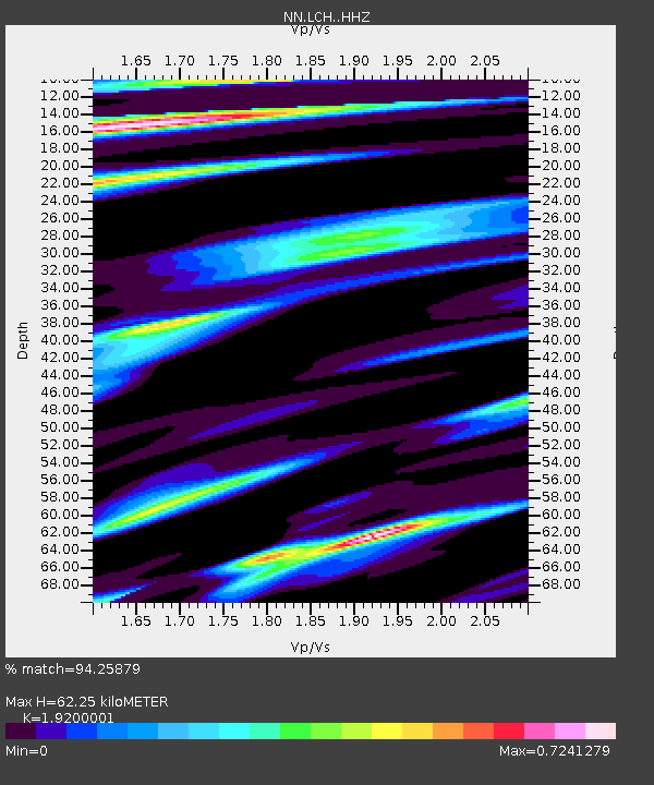
| Estimated Moho Depth: |
62.25 km |
| Estimated Crust Vp/Vs: |
1.92 |
| Assumed Crust Vp: |
6.279 km/s |
| Estimated Crust Vs: |
3.27 km/s |
| Estimated Crust Poisson's Ratio: |
0.31 |
|
| Radial Match: |
94.25879 % |
| Radial Bump: |
400 |
| Transverse Match: |
87.06734 % |
| Transverse Bump: |
400 |
| SOD ConfigId: |
11737051 |
| Insert Time: |
2019-04-26 06:03:13.993 +0000 |
| GWidth: |
2.5 |
| Max Bumps: |
400 |
| Tol: |
0.001 |
|

Signal To Noise
| Channel | StoN | STA | LTA |
| NN:LCH: :HHZ:20161208T17:51:07.257991Z | 26.231869 | 7.0148412E-6 | 2.6741677E-7 |
| NN:LCH: :HHN:20161208T17:51:07.257991Z | 3.3212504 | 6.8380484E-7 | 2.0588777E-7 |
| NN:LCH: :HHE:20161208T17:51:07.257991Z | 6.213264 | 1.8213781E-6 | 2.9314353E-7 |
| Arrivals |
| Ps | 9.3 SECOND |
| PpPs | 28 SECOND |
| PsPs/PpSs | 38 SECOND |


