You are here: Home > Network List > IW - Intermountain West Stations List
> Station MOOW Moose Ponds, Wyoming, USA > Earthquake Result Viewer
MOOW Moose Ponds, Wyoming, USA - Earthquake Result Viewer
| Earthquake location: |
Vanuatu Islands |
| Earthquake latitude/longitude: |
-14.8/167.3 |
| Earthquake time(UTC): |
2015/10/20 (293) 21:52:02 GMT |
| Earthquake Depth: |
127 km |
| Earthquake Magnitude: |
7.1 MWW, 7.3 MI |
| Earthquake Catalog/Contributor: |
NEIC PDE/NEIC COMCAT |
|
| Network: |
IW Intermountain West |
| Station: |
MOOW Moose Ponds, Wyoming, USA |
| Lat/Lon: |
43.75 N/110.74 W |
| Elevation: |
2128 m |
|
| Distance: |
94.4 deg |
| Az: |
46.03 deg |
| Baz: |
253.822 deg |
| Ray Param: |
0.040955156 |
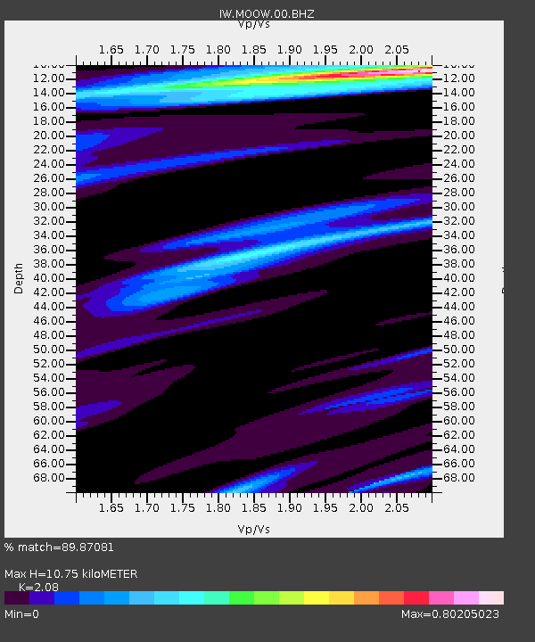
| Estimated Moho Depth: |
10.75 km |
| Estimated Crust Vp/Vs: |
2.08 |
| Assumed Crust Vp: |
6.207 km/s |
| Estimated Crust Vs: |
2.984 km/s |
| Estimated Crust Poisson's Ratio: |
0.35 |
|
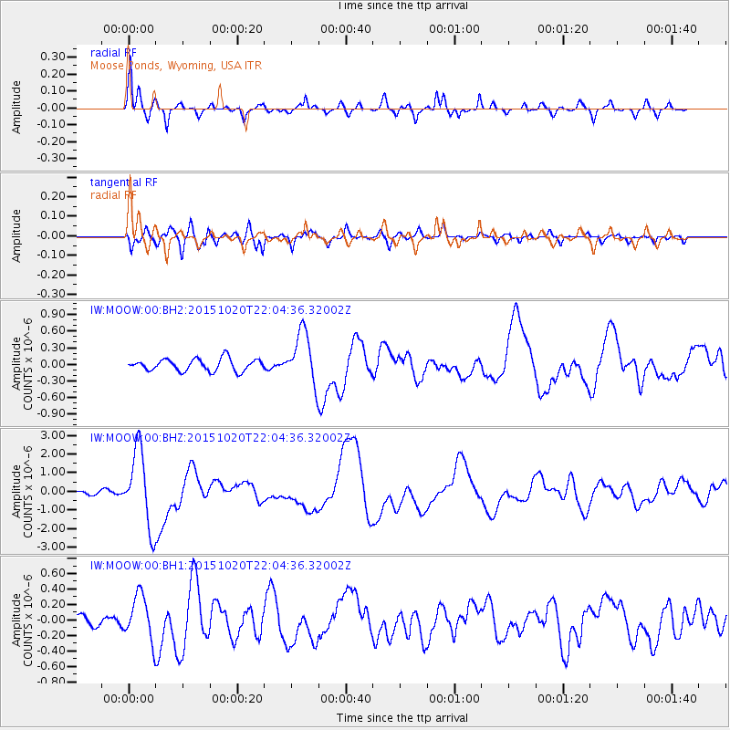
| Radial Match: |
89.87081 % |
| Radial Bump: |
400 |
| Transverse Match: |
82.47039 % |
| Transverse Bump: |
400 |
| SOD ConfigId: |
1259291 |
| Insert Time: |
2015-11-03 22:21:18.264 +0000 |
| GWidth: |
2.5 |
| Max Bumps: |
400 |
| Tol: |
0.001 |
|
Signal To Noise
| Channel | StoN | STA | LTA |
| IW:MOOW:00:BHZ:20151020T22:04:36.32002Z | 19.685722 | 2.0585994E-6 | 1.04573225E-7 |
| IW:MOOW:00:BH1:20151020T22:04:36.32002Z | 4.2291827 | 2.9253047E-7 | 6.91695E-8 |
| IW:MOOW:00:BH2:20151020T22:04:36.32002Z | 4.314039 | 4.735531E-7 | 1.0977023E-7 |
| Arrivals |
| Ps | 1.9 SECOND |
| PpPs | 5.3 SECOND |
| PsPs/PpSs | 7.2 SECOND |


