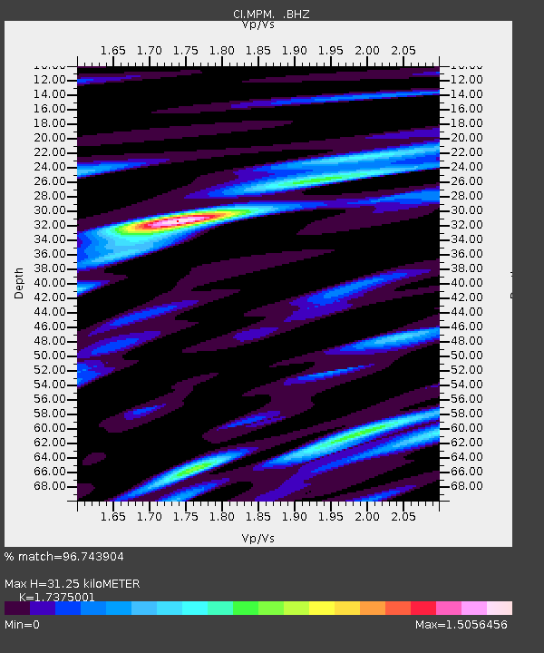
MPM Manuel Prospect Mine, California, USA - Earthquake Result Viewer
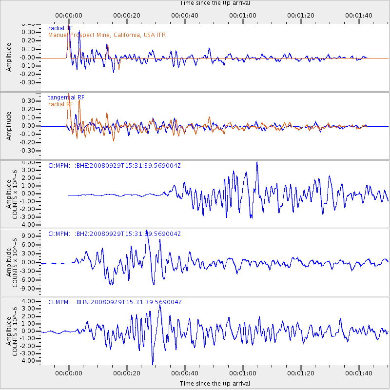
Earthquake location: Kermadec Islands, New Zealand
Earthquake latitude/longitude: -29.8/-177.7
Earthquake time(UTC): 2008/09/29 (273) 15:19:31 GMT
Earthquake Depth: 36 km
Earthquake Magnitude: 6.5 MB, 6.7 MS, 7.0 MW, 7.0 MW
Earthquake Catalog/Contributor: WHDF/NEIC
Network: CI Caltech Regional Seismic Network
Station: MPM Manuel Prospect Mine, California, USA
Lat/Lon: 36.06 N/117.49 W
Elevation: 185 m
Distance: 86.5 deg
Az: 44.782 deg
Baz: 229.108 deg
Ray Param: 0.0439503
Estimated Moho Depth: 31.25 km
Estimated Crust Vp/Vs: 1.74
Assumed Crust Vp: 6.279 km/s
Estimated Crust Vs: 3.614 km/s
Estimated Crust Poisson's Ratio: 0.25
Radial Match: 96.743904 %
Radial Bump: 400
Transverse Match: 93.1465 %
Transverse Bump: 400
SOD ConfigId: 2560
Insert Time: 2010-03-05 20:19:07.535 +0000
GWidth: 2.5
Max Bumps: 400
Tol: 0.001

Signal To Noise

ChannelStoNSTALTA
CI:MPM: :BHZ:20080929T15:31:39.569004Z8.88266.825639E-77.68428E-8
CI:MPM: :BHN:20080929T15:31:39.569004Z2.32652281.4733031E-76.33264E-8
CI:MPM: :BHE:20080929T15:31:39.569004Z2.7514561.6300895E-75.9244613E-8
Arrivals
Ps3.8 SECOND
PpPs13 SECOND
PsPs/PpSs17 SECOND