You are here: Home > Network List > RM - Regional Integrated Multi Hazard Early Warning System Stations List
> Station SLV Son La Vietnam > Earthquake Result Viewer
SLV Son La Vietnam - Earthquake Result Viewer
| Earthquake location: |
Solomon Islands |
| Earthquake latitude/longitude: |
-10.7/161.3 |
| Earthquake time(UTC): |
2016/12/08 (343) 17:38:46 GMT |
| Earthquake Depth: |
41 km |
| Earthquake Magnitude: |
7.8 mww |
| Earthquake Catalog/Contributor: |
NEIC PDE/us |
|
| Network: |
RM Regional Integrated Multi Hazard Early Warning System |
| Station: |
SLV Son La Vietnam |
| Lat/Lon: |
21.33 N/103.91 E |
| Elevation: |
630 m |
|
| Distance: |
64.7 deg |
| Az: |
299.68 deg |
| Baz: |
113.663 deg |
| Ray Param: |
0.058659382 |
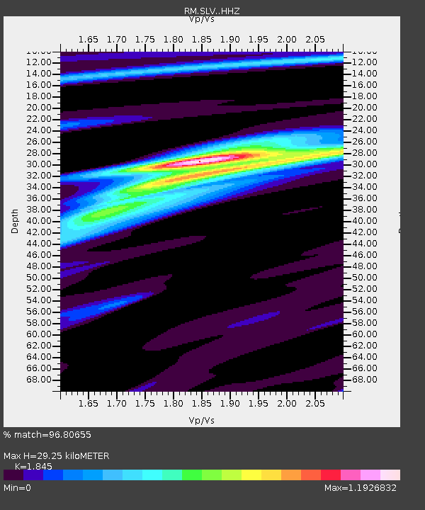
| Estimated Moho Depth: |
29.25 km |
| Estimated Crust Vp/Vs: |
1.85 |
| Assumed Crust Vp: |
6.35 km/s |
| Estimated Crust Vs: |
3.442 km/s |
| Estimated Crust Poisson's Ratio: |
0.29 |
|
| Radial Match: |
96.80655 % |
| Radial Bump: |
374 |
| Transverse Match: |
87.28692 % |
| Transverse Bump: |
400 |
| SOD ConfigId: |
11737051 |
| Insert Time: |
2019-04-26 06:04:27.053 +0000 |
| GWidth: |
2.5 |
| Max Bumps: |
400 |
| Tol: |
0.001 |
|

Signal To Noise
| Channel | StoN | STA | LTA |
| RM:SLV: :HHZ:20161208T17:48:49.648005Z | 26.454605 | 5.627613E-6 | 2.1272716E-7 |
| RM:SLV: :HHN:20161208T17:48:49.648005Z | 7.4098277 | 6.7793917E-7 | 9.149189E-8 |
| RM:SLV: :HHE:20161208T17:48:49.648005Z | 11.752078 | 2.2024226E-6 | 1.8740708E-7 |
| Arrivals |
| Ps | 4.0 SECOND |
| PpPs | 13 SECOND |
| PsPs/PpSs | 17 SECOND |


