You are here: Home > Network List > CI - Caltech Regional Seismic Network Stations List
> Station MPM Manuel Prospect Mine, California, USA > Earthquake Result Viewer
MPM Manuel Prospect Mine, California, USA - Earthquake Result Viewer
| Earthquake location: |
Near Coast Of Central Chile |
| Earthquake latitude/longitude: |
-29.5/-71.7 |
| Earthquake time(UTC): |
1998/09/03 (246) 17:37:58 GMT |
| Earthquake Depth: |
27 km |
| Earthquake Magnitude: |
6.2 MB, 6.6 MS, 6.5 UNKNOWN, 6.4 ME |
| Earthquake Catalog/Contributor: |
WHDF/NEIC |
|
| Network: |
CI Caltech Regional Seismic Network |
| Station: |
MPM Manuel Prospect Mine, California, USA |
| Lat/Lon: |
36.06 N/117.49 W |
| Elevation: |
185 m |
|
| Distance: |
78.1 deg |
| Az: |
323.6 deg |
| Baz: |
140.302 deg |
| Ray Param: |
0.04984147 |
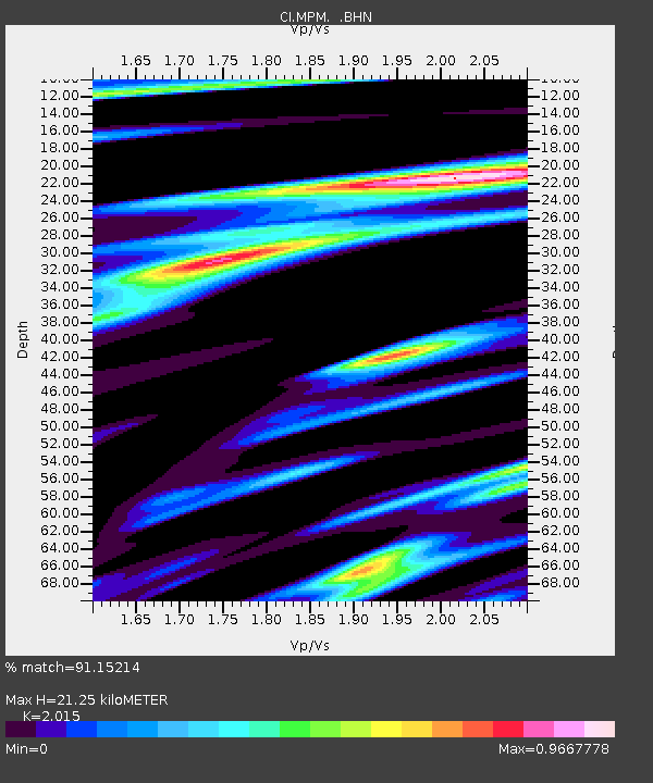
| Estimated Moho Depth: |
21.25 km |
| Estimated Crust Vp/Vs: |
2.02 |
| Assumed Crust Vp: |
6.279 km/s |
| Estimated Crust Vs: |
3.116 km/s |
| Estimated Crust Poisson's Ratio: |
0.34 |
|
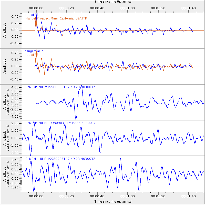
| Radial Match: |
91.15214 % |
| Radial Bump: |
400 |
| Transverse Match: |
87.47056 % |
| Transverse Bump: |
400 |
| SOD ConfigId: |
9875 |
| Insert Time: |
2010-03-05 20:19:20.770 +0000 |
| GWidth: |
2.5 |
| Max Bumps: |
400 |
| Tol: |
0.001 |
|
Signal To Noise
| Channel | StoN | STA | LTA |
| CI:MPM: :BHN:19980903T17:49:23.403003Z | 2.9713695 | 5.6548646E-7 | 1.9031172E-7 |
| CI:MPM: :BHE:19980903T17:49:23.403003Z | 3.6761205 | 6.765136E-7 | 1.8402922E-7 |
| CI:MPM: :BHZ:19980903T17:49:23.403003Z | 4.7086887 | 2.3166572E-6 | 4.919963E-7 |
| Arrivals |
| Ps | 3.5 SECOND |
| PpPs | 10.0 SECOND |
| PsPs/PpSs | 13 SECOND |


