You are here: Home > Network List > CI - Caltech Regional Seismic Network Stations List
> Station MPM Manuel Prospect Mine, California, USA > Earthquake Result Viewer
MPM Manuel Prospect Mine, California, USA - Earthquake Result Viewer
| Earthquake location: |
Mariana Islands Region |
| Earthquake latitude/longitude: |
17.1/148.1 |
| Earthquake time(UTC): |
1998/08/30 (242) 01:48:08 GMT |
| Earthquake Depth: |
33 km |
| Earthquake Magnitude: |
6.0 MB, 6.1 MS, 6.2 UNKNOWN, 5.9 ME |
| Earthquake Catalog/Contributor: |
WHDF/NEIC |
|
| Network: |
CI Caltech Regional Seismic Network |
| Station: |
MPM Manuel Prospect Mine, California, USA |
| Lat/Lon: |
36.06 N/117.49 W |
| Elevation: |
185 m |
|
| Distance: |
83.6 deg |
| Az: |
54.395 deg |
| Baz: |
286.335 deg |
| Ray Param: |
0.04605147 |
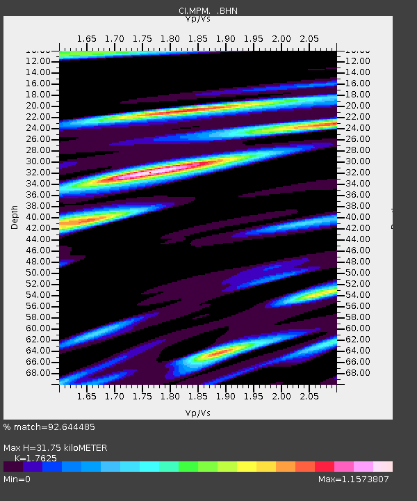
| Estimated Moho Depth: |
31.75 km |
| Estimated Crust Vp/Vs: |
1.76 |
| Assumed Crust Vp: |
6.279 km/s |
| Estimated Crust Vs: |
3.562 km/s |
| Estimated Crust Poisson's Ratio: |
0.26 |
|
| Radial Match: |
92.644485 % |
| Radial Bump: |
400 |
| Transverse Match: |
84.43966 % |
| Transverse Bump: |
400 |
| SOD ConfigId: |
9875 |
| Insert Time: |
2010-03-05 20:19:21.657 +0000 |
| GWidth: |
2.5 |
| Max Bumps: |
400 |
| Tol: |
0.001 |
|
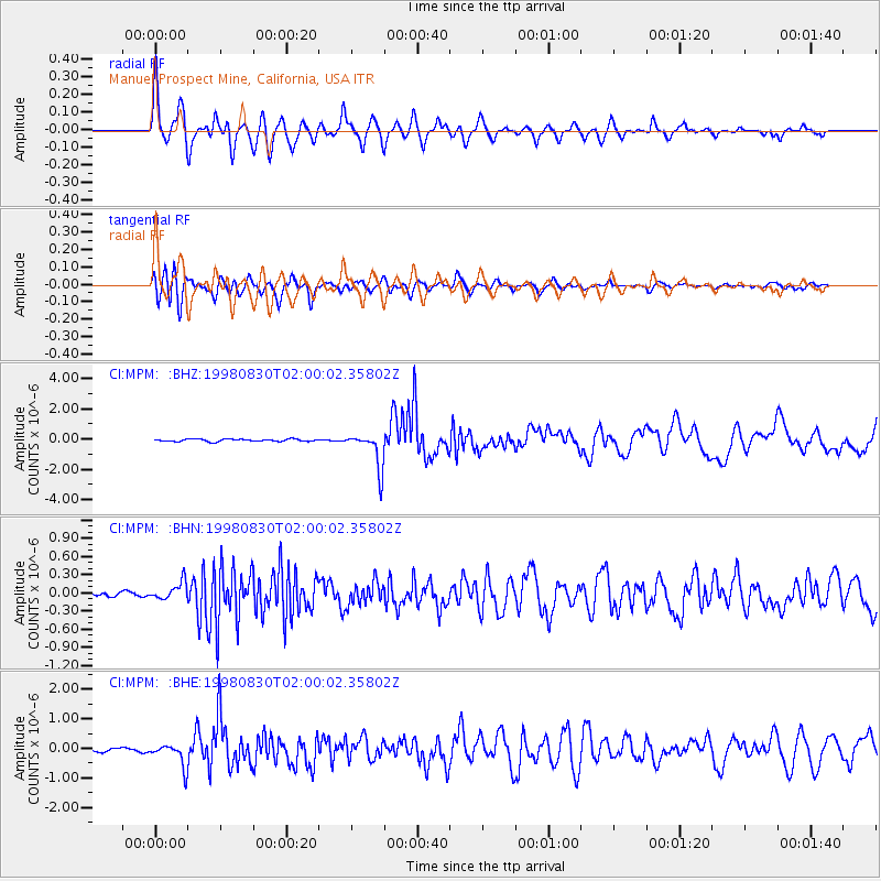
Signal To Noise
| Channel | StoN | STA | LTA |
| CI:MPM: :BHN:19980830T02:00:02.35802Z | 3.149651 | 1.4652163E-7 | 4.6519958E-8 |
| CI:MPM: :BHE:19980830T02:00:02.35802Z | 4.86728 | 3.9464314E-7 | 8.1080834E-8 |
| CI:MPM: :BHZ:19980830T02:00:02.35802Z | 15.461948 | 1.2193628E-6 | 7.886217E-8 |
| Arrivals |
| Ps | 4.0 SECOND |
| PpPs | 14 SECOND |
| PsPs/PpSs | 18 SECOND |


