You are here: Home > Network List > CI - Caltech Regional Seismic Network Stations List
> Station MPM Manuel Prospect Mine, California, USA > Earthquake Result Viewer
MPM Manuel Prospect Mine, California, USA - Earthquake Result Viewer
| Earthquake location: |
Off Coast Of Central America |
| Earthquake latitude/longitude: |
11.7/-88.0 |
| Earthquake time(UTC): |
1998/08/23 (235) 13:57:15 GMT |
| Earthquake Depth: |
55 km |
| Earthquake Magnitude: |
5.7 MB, 6.3 MS, 6.8 UNKNOWN, 6.7 MW |
| Earthquake Catalog/Contributor: |
WHDF/NEIC |
|
| Network: |
CI Caltech Regional Seismic Network |
| Station: |
MPM Manuel Prospect Mine, California, USA |
| Lat/Lon: |
36.06 N/117.49 W |
| Elevation: |
185 m |
|
| Distance: |
36.0 deg |
| Az: |
317.34 deg |
| Baz: |
124.99 deg |
| Ray Param: |
0.07676819 |
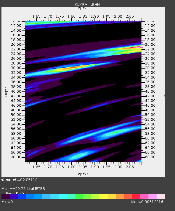
| Estimated Moho Depth: |
20.75 km |
| Estimated Crust Vp/Vs: |
2.10 |
| Assumed Crust Vp: |
6.279 km/s |
| Estimated Crust Vs: |
2.993 km/s |
| Estimated Crust Poisson's Ratio: |
0.35 |
|
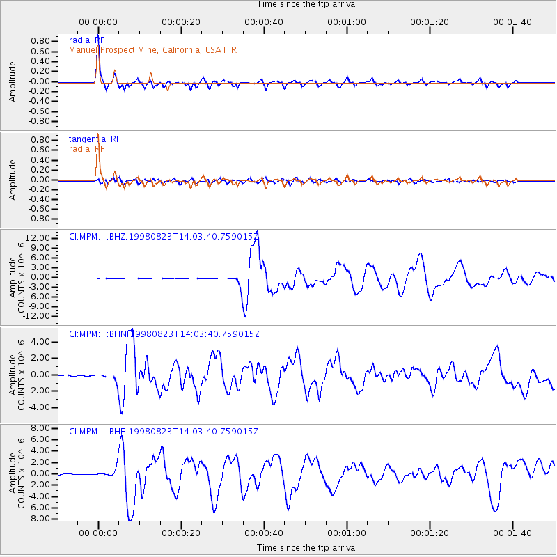
| Radial Match: |
92.85118 % |
| Radial Bump: |
393 |
| Transverse Match: |
66.077255 % |
| Transverse Bump: |
400 |
| SOD ConfigId: |
9875 |
| Insert Time: |
2010-03-05 20:19:23.583 +0000 |
| GWidth: |
2.5 |
| Max Bumps: |
400 |
| Tol: |
0.001 |
|
Signal To Noise
| Channel | StoN | STA | LTA |
| CI:MPM: :BHN:19980823T14:03:40.759015Z | 10.079945 | 5.2372894E-7 | 5.195752E-8 |
| CI:MPM: :BHE:19980823T14:03:40.759015Z | 11.383897 | 8.7365135E-7 | 7.674449E-8 |
| CI:MPM: :BHZ:19980823T14:03:40.759015Z | 22.045279 | 1.8538353E-6 | 8.409217E-8 |
| Arrivals |
| Ps | 3.9 SECOND |
| PpPs | 9.6 SECOND |
| PsPs/PpSs | 13 SECOND |


