You are here: Home > Network List > TA - USArray Transportable Network (new EarthScope stations) Stations List
> Station C24K Franklin Bluffs, AK, USA > Earthquake Result Viewer
C24K Franklin Bluffs, AK, USA - Earthquake Result Viewer
| Earthquake location: |
Solomon Islands |
| Earthquake latitude/longitude: |
-10.7/161.3 |
| Earthquake time(UTC): |
2016/12/08 (343) 17:38:46 GMT |
| Earthquake Depth: |
41 km |
| Earthquake Magnitude: |
7.8 mww |
| Earthquake Catalog/Contributor: |
NEIC PDE/us |
|
| Network: |
TA USArray Transportable Network (new EarthScope stations) |
| Station: |
C24K Franklin Bluffs, AK, USA |
| Lat/Lon: |
69.72 N/148.70 W |
| Elevation: |
115 m |
|
| Distance: |
87.3 deg |
| Az: |
15.502 deg |
| Baz: |
228.893 deg |
| Ray Param: |
0.04339413 |
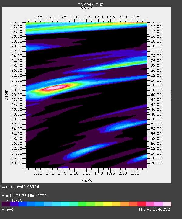
| Estimated Moho Depth: |
36.75 km |
| Estimated Crust Vp/Vs: |
1.72 |
| Assumed Crust Vp: |
6.316 km/s |
| Estimated Crust Vs: |
3.683 km/s |
| Estimated Crust Poisson's Ratio: |
0.24 |
|
| Radial Match: |
95.68506 % |
| Radial Bump: |
400 |
| Transverse Match: |
88.18826 % |
| Transverse Bump: |
400 |
| SOD ConfigId: |
11737051 |
| Insert Time: |
2019-04-26 06:04:54.793 +0000 |
| GWidth: |
2.5 |
| Max Bumps: |
400 |
| Tol: |
0.001 |
|

Signal To Noise
| Channel | StoN | STA | LTA |
| TA:C24K: :BHZ:20161208T17:50:57.374995Z | 38.914524 | 9.733446E-6 | 2.5012375E-7 |
| TA:C24K: :BHN:20161208T17:50:57.374995Z | 7.140118 | 2.0057032E-6 | 2.8090614E-7 |
| TA:C24K: :BHE:20161208T17:50:57.374995Z | 7.215687 | 2.1987676E-6 | 3.047205E-7 |
| Arrivals |
| Ps | 4.3 SECOND |
| PpPs | 15 SECOND |
| PsPs/PpSs | 20 SECOND |


