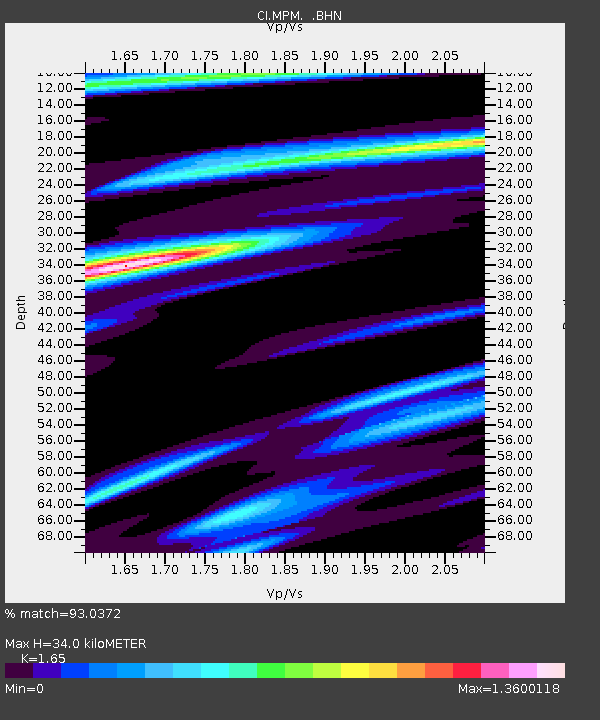
MPM Manuel Prospect Mine, California, USA - Earthquake Result Viewer
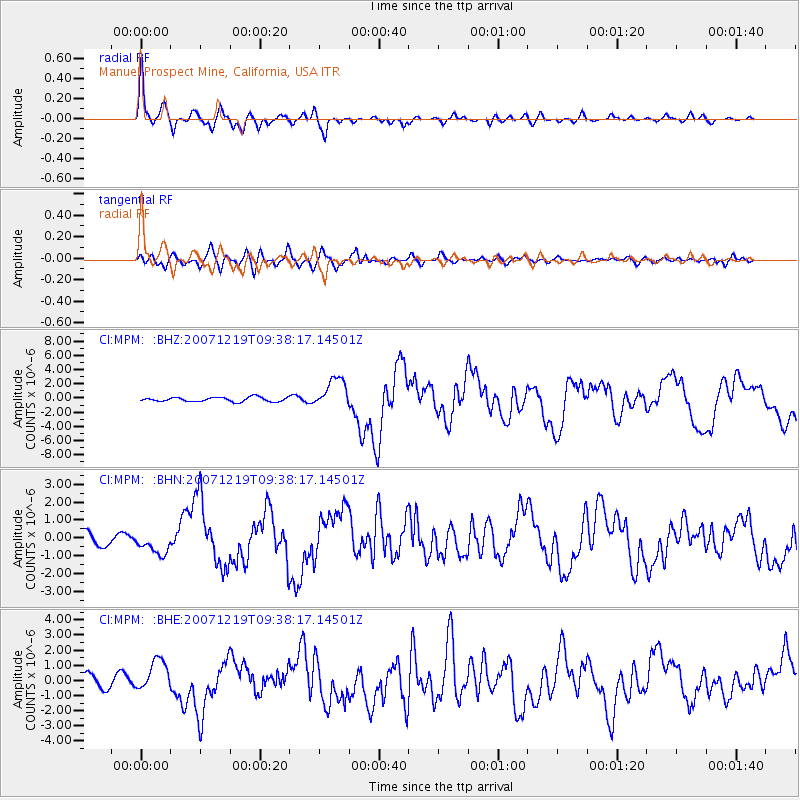
Earthquake location: Andreanof Islands, Aleutian Is.
Earthquake latitude/longitude: 51.4/-179.5
Earthquake time(UTC): 2007/12/19 (353) 09:30:27 GMT
Earthquake Depth: 29 km
Earthquake Magnitude: 6.4 MB, 7.1 MS, 7.1 MW, 7.0 MW
Earthquake Catalog/Contributor: WHDF/NEIC
Network: CI Caltech Regional Seismic Network
Station: MPM Manuel Prospect Mine, California, USA
Lat/Lon: 36.06 N/117.49 W
Elevation: 185 m
Distance: 46.0 deg
Az: 84.306 deg
Baz: 309.655 deg
Ray Param: 0.070869245
Estimated Moho Depth: 34.0 km
Estimated Crust Vp/Vs: 1.65
Assumed Crust Vp: 6.279 km/s
Estimated Crust Vs: 3.805 km/s
Estimated Crust Poisson's Ratio: 0.21
Radial Match: 93.0372 %
Radial Bump: 400
Transverse Match: 70.2816 %
Transverse Bump: 400
SOD ConfigId: 2564
Insert Time: 2010-03-05 20:19:26.876 +0000
GWidth: 2.5
Max Bumps: 400
Tol: 0.001

Signal To Noise

ChannelStoNSTALTA
CI:MPM: :BHN:20071219T09:38:17.14501Z1.7498476.1323163E-73.504487E-7
CI:MPM: :BHE:20071219T09:38:17.14501Z2.09322141.0505292E-65.01872E-7
CI:MPM: :BHZ:20071219T09:38:17.14501Z7.03158242.1106032E-63.0016048E-7
Arrivals
Ps3.8 SECOND
PpPs13 SECOND
PsPs/PpSs17 SECOND