You are here: Home > Network List > TA - USArray Transportable Network (new EarthScope stations) Stations List
> Station I23K Minto, Yukon-Koyukuk, AK, USA > Earthquake Result Viewer
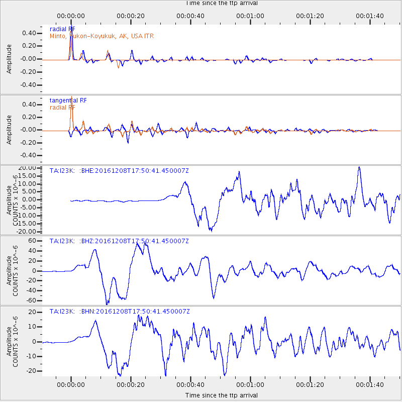
I23K Minto, Yukon-Koyukuk, AK, USA - Earthquake Result Viewer
| Earthquake location: |
Solomon Islands |
| Earthquake latitude/longitude: |
-10.7/161.3 |
| Earthquake time(UTC): |
2016/12/08 (343) 17:38:46 GMT |
| Earthquake Depth: |
41 km |
| Earthquake Magnitude: |
7.8 mww |
| Earthquake Catalog/Contributor: |
NEIC PDE/us |
|
| Network: |
TA USArray Transportable Network (new EarthScope stations) |
| Station: |
I23K Minto, Yukon-Koyukuk, AK, USA |
| Lat/Lon: |
65.15 N/149.36 W |
| Elevation: |
149 m |
|
| Distance: |
84.0 deg |
| Az: |
18.795 deg |
| Baz: |
228.535 deg |
| Ray Param: |
0.04570631 |
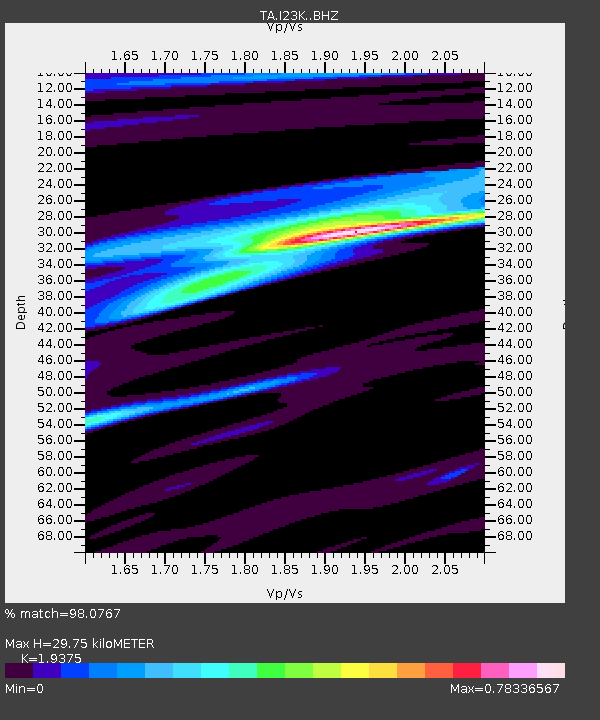
| Estimated Moho Depth: |
29.75 km |
| Estimated Crust Vp/Vs: |
1.94 |
| Assumed Crust Vp: |
6.566 km/s |
| Estimated Crust Vs: |
3.389 km/s |
| Estimated Crust Poisson's Ratio: |
0.32 |
|
| Radial Match: |
98.0767 % |
| Radial Bump: |
171 |
| Transverse Match: |
92.44207 % |
| Transverse Bump: |
400 |
| SOD ConfigId: |
11737051 |
| Insert Time: |
2019-04-26 06:05:19.676 +0000 |
| GWidth: |
2.5 |
| Max Bumps: |
400 |
| Tol: |
0.001 |
|
Signal To Noise
| Channel | StoN | STA | LTA |
| TA:I23K: :BHZ:20161208T17:50:41.450007Z | 39.653305 | 9.491977E-6 | 2.3937417E-7 |
| TA:I23K: :BHN:20161208T17:50:41.450007Z | 16.000998 | 2.830096E-6 | 1.7686999E-7 |
| TA:I23K: :BHE:20161208T17:50:41.450007Z | 9.734757 | 2.3826526E-6 | 2.4475727E-7 |
| Arrivals |
| Ps | 4.4 SECOND |
| PpPs | 13 SECOND |
| PsPs/PpSs | 17 SECOND |


