You are here: Home > Network List > TA - USArray Transportable Network (new EarthScope stations) Stations List
> Station I27K Kandik River, AK, USA > Earthquake Result Viewer
I27K Kandik River, AK, USA - Earthquake Result Viewer
| Earthquake location: |
Solomon Islands |
| Earthquake latitude/longitude: |
-10.7/161.3 |
| Earthquake time(UTC): |
2016/12/08 (343) 17:38:46 GMT |
| Earthquake Depth: |
41 km |
| Earthquake Magnitude: |
7.8 mww |
| Earthquake Catalog/Contributor: |
NEIC PDE/us |
|
| Network: |
TA USArray Transportable Network (new EarthScope stations) |
| Station: |
I27K Kandik River, AK, USA |
| Lat/Lon: |
65.60 N/141.62 W |
| Elevation: |
874 m |
|
| Distance: |
86.9 deg |
| Az: |
20.431 deg |
| Baz: |
235.699 deg |
| Ray Param: |
0.04367441 |
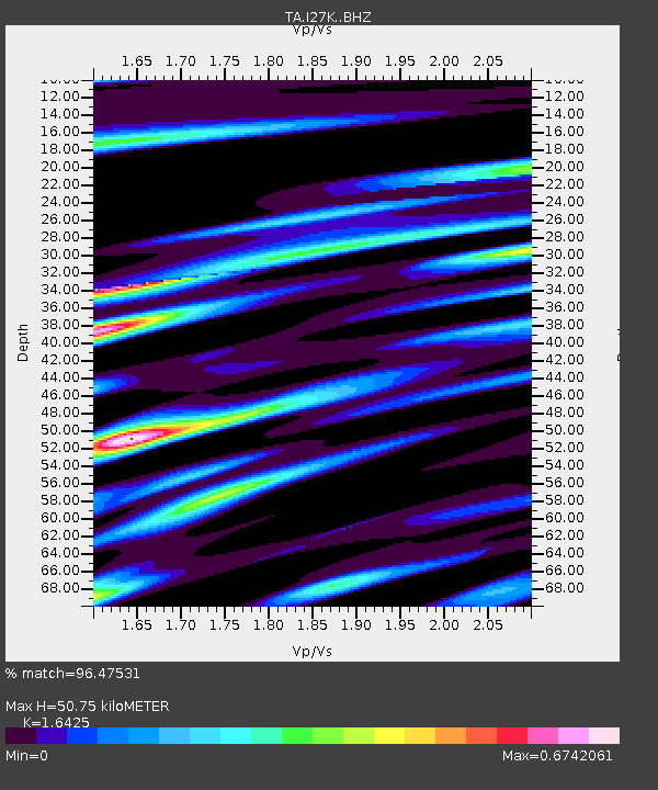
| Estimated Moho Depth: |
50.75 km |
| Estimated Crust Vp/Vs: |
1.64 |
| Assumed Crust Vp: |
6.566 km/s |
| Estimated Crust Vs: |
3.998 km/s |
| Estimated Crust Poisson's Ratio: |
0.21 |
|
| Radial Match: |
96.47531 % |
| Radial Bump: |
400 |
| Transverse Match: |
90.120636 % |
| Transverse Bump: |
400 |
| SOD ConfigId: |
11737051 |
| Insert Time: |
2019-04-26 06:05:20.738 +0000 |
| GWidth: |
2.5 |
| Max Bumps: |
400 |
| Tol: |
0.001 |
|

Signal To Noise
| Channel | StoN | STA | LTA |
| TA:I27K: :BHZ:20161208T17:50:55.52502Z | 33.296455 | 8.693751E-6 | 2.611014E-7 |
| TA:I27K: :BHN:20161208T17:50:55.52502Z | 10.80017 | 1.867341E-6 | 1.7289922E-7 |
| TA:I27K: :BHE:20161208T17:50:55.52502Z | 14.279526 | 2.5626537E-6 | 1.794635E-7 |
| Arrivals |
| Ps | 5.1 SECOND |
| PpPs | 20 SECOND |
| PsPs/PpSs | 25 SECOND |


