You are here: Home > Network List > TA - USArray Transportable Network (new EarthScope stations) Stations List
> Station N25K Chitina, Valdez-Cordova, AK, USA > Earthquake Result Viewer
N25K Chitina, Valdez-Cordova, AK, USA - Earthquake Result Viewer
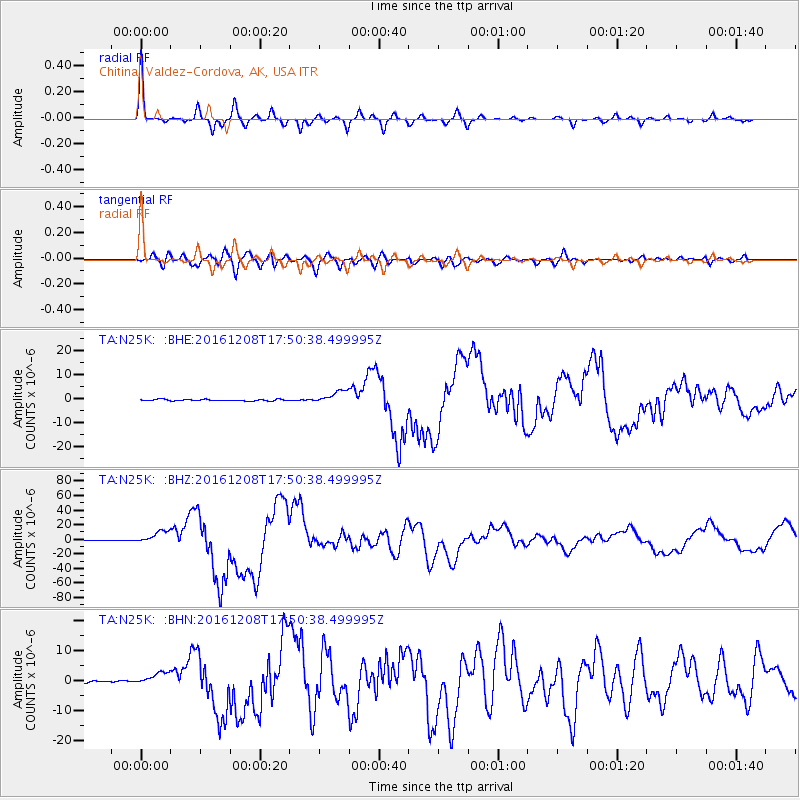
| Earthquake location: |
Solomon Islands |
| Earthquake latitude/longitude: |
-10.7/161.3 |
| Earthquake time(UTC): |
2016/12/08 (343) 17:38:46 GMT |
| Earthquake Depth: |
41 km |
| Earthquake Magnitude: |
7.8 mww |
| Earthquake Catalog/Contributor: |
NEIC PDE/us |
|
| Network: |
TA USArray Transportable Network (new EarthScope stations) |
| Station: |
N25K Chitina, Valdez-Cordova, AK, USA |
| Lat/Lon: |
61.61 N/144.60 W |
| Elevation: |
1087 m |
|
| Distance: |
83.5 deg |
| Az: |
22.93 deg |
| Baz: |
233.24 deg |
| Ray Param: |
0.04611379 |
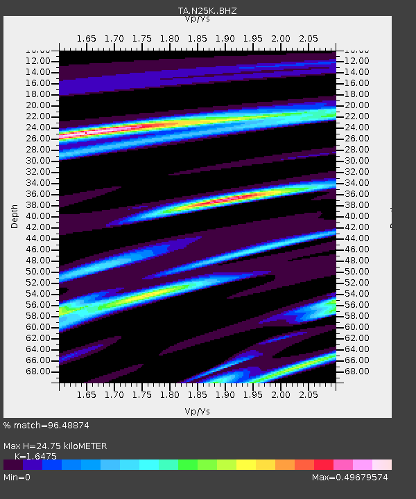
| Estimated Moho Depth: |
24.75 km |
| Estimated Crust Vp/Vs: |
1.65 |
| Assumed Crust Vp: |
6.566 km/s |
| Estimated Crust Vs: |
3.986 km/s |
| Estimated Crust Poisson's Ratio: |
0.21 |
|
| Radial Match: |
96.48874 % |
| Radial Bump: |
257 |
| Transverse Match: |
86.21944 % |
| Transverse Bump: |
400 |
| SOD ConfigId: |
11737051 |
| Insert Time: |
2019-04-26 06:05:40.324 +0000 |
| GWidth: |
2.5 |
| Max Bumps: |
400 |
| Tol: |
0.001 |
|
Signal To Noise
| Channel | StoN | STA | LTA |
| TA:N25K: :BHZ:20161208T17:50:38.499995Z | 35.952507 | 8.950586E-6 | 2.489558E-7 |
| TA:N25K: :BHN:20161208T17:50:38.499995Z | 6.6731706 | 2.140967E-6 | 3.2083204E-7 |
| TA:N25K: :BHE:20161208T17:50:38.499995Z | 8.47306 | 2.712047E-6 | 3.2007884E-7 |
| Arrivals |
| Ps | 2.5 SECOND |
| PpPs | 9.7 SECOND |
| PsPs/PpSs | 12 SECOND |


