You are here: Home > Network List > TA - USArray Transportable Network (new EarthScope stations) Stations List
> Station P16K Nushagak River, AK, USA > Earthquake Result Viewer
P16K Nushagak River, AK, USA - Earthquake Result Viewer
| Earthquake location: |
Solomon Islands |
| Earthquake latitude/longitude: |
-10.7/161.3 |
| Earthquake time(UTC): |
2016/12/08 (343) 17:38:46 GMT |
| Earthquake Depth: |
41 km |
| Earthquake Magnitude: |
7.8 mww |
| Earthquake Catalog/Contributor: |
NEIC PDE/us |
|
| Network: |
TA USArray Transportable Network (new EarthScope stations) |
| Station: |
P16K Nushagak River, AK, USA |
| Lat/Lon: |
59.03 N/157.99 W |
| Elevation: |
86 m |
|
| Distance: |
76.8 deg |
| Az: |
20.254 deg |
| Baz: |
221.148 deg |
| Ray Param: |
0.05066718 |
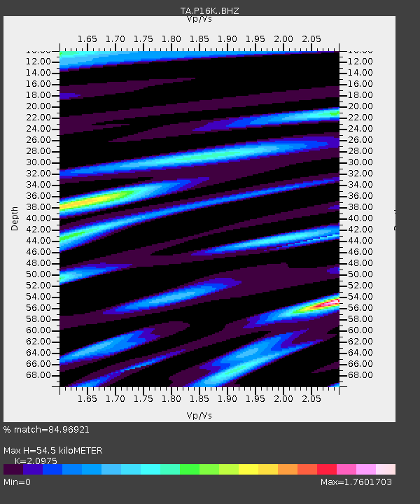
| Estimated Moho Depth: |
54.5 km |
| Estimated Crust Vp/Vs: |
2.10 |
| Assumed Crust Vp: |
6.276 km/s |
| Estimated Crust Vs: |
2.992 km/s |
| Estimated Crust Poisson's Ratio: |
0.35 |
|
| Radial Match: |
84.96921 % |
| Radial Bump: |
400 |
| Transverse Match: |
85.094246 % |
| Transverse Bump: |
400 |
| SOD ConfigId: |
11737051 |
| Insert Time: |
2019-04-26 06:05:51.563 +0000 |
| GWidth: |
2.5 |
| Max Bumps: |
400 |
| Tol: |
0.001 |
|

Signal To Noise
| Channel | StoN | STA | LTA |
| TA:P16K: :BHZ:20161208T17:50:02.924983Z | 26.70263 | 8.996304E-6 | 3.3690708E-7 |
| TA:P16K: :BHN:20161208T17:50:02.924983Z | 2.759804 | 4.2088996E-6 | 1.5250718E-6 |
| TA:P16K: :BHE:20161208T17:50:02.924983Z | 2.1552346 | 2.2873696E-6 | 1.0613088E-6 |
| Arrivals |
| Ps | 9.8 SECOND |
| PpPs | 26 SECOND |
| PsPs/PpSs | 36 SECOND |


