You are here: Home > Network List > TA - USArray Transportable Network (new EarthScope stations) Stations List
> Station Q18K Katmai Hardscrabble Creek, AK, USA > Earthquake Result Viewer
Q18K Katmai Hardscrabble Creek, AK, USA - Earthquake Result Viewer
| Earthquake location: |
Solomon Islands |
| Earthquake latitude/longitude: |
-10.7/161.3 |
| Earthquake time(UTC): |
2016/12/08 (343) 17:38:46 GMT |
| Earthquake Depth: |
41 km |
| Earthquake Magnitude: |
7.8 mww |
| Earthquake Catalog/Contributor: |
NEIC PDE/us |
|
| Network: |
TA USArray Transportable Network (new EarthScope stations) |
| Station: |
Q18K Katmai Hardscrabble Creek, AK, USA |
| Lat/Lon: |
58.65 N/155.01 W |
| Elevation: |
1250 m |
|
| Distance: |
77.6 deg |
| Az: |
21.691 deg |
| Baz: |
224.014 deg |
| Ray Param: |
0.050150976 |
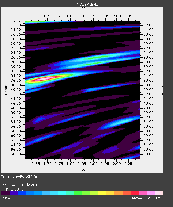
| Estimated Moho Depth: |
35.0 km |
| Estimated Crust Vp/Vs: |
1.69 |
| Assumed Crust Vp: |
6.438 km/s |
| Estimated Crust Vs: |
3.815 km/s |
| Estimated Crust Poisson's Ratio: |
0.23 |
|
| Radial Match: |
96.52478 % |
| Radial Bump: |
400 |
| Transverse Match: |
89.88342 % |
| Transverse Bump: |
400 |
| SOD ConfigId: |
11737051 |
| Insert Time: |
2019-04-26 06:05:59.763 +0000 |
| GWidth: |
2.5 |
| Max Bumps: |
400 |
| Tol: |
0.001 |
|

Signal To Noise
| Channel | StoN | STA | LTA |
| TA:Q18K: :BHZ:20161208T17:50:07.224971Z | 34.526554 | 1.1130633E-5 | 3.2237892E-7 |
| TA:Q18K: :BHN:20161208T17:50:07.224971Z | 10.078077 | 3.6112938E-6 | 3.5833162E-7 |
| TA:Q18K: :BHE:20161208T17:50:07.224971Z | 7.1751757 | 3.153724E-6 | 4.3953267E-7 |
| Arrivals |
| Ps | 3.9 SECOND |
| PpPs | 14 SECOND |
| PsPs/PpSs | 18 SECOND |


