You are here: Home > Network List > TA - USArray Transportable Network (new EarthScope stations) Stations List
> Station R16K Pilot Point, AK, USA > Earthquake Result Viewer
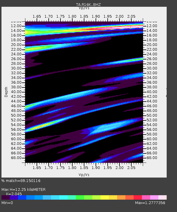
R16K Pilot Point, AK, USA - Earthquake Result Viewer
| Earthquake location: |
Solomon Islands |
| Earthquake latitude/longitude: |
-10.7/161.3 |
| Earthquake time(UTC): |
2016/12/08 (343) 17:38:46 GMT |
| Earthquake Depth: |
41 km |
| Earthquake Magnitude: |
7.8 mww |
| Earthquake Catalog/Contributor: |
NEIC PDE/us |
|
| Network: |
TA USArray Transportable Network (new EarthScope stations) |
| Station: |
R16K Pilot Point, AK, USA |
| Lat/Lon: |
57.57 N/157.57 W |
| Elevation: |
38 m |
|
| Distance: |
75.9 deg |
| Az: |
21.424 deg |
| Baz: |
221.778 deg |
| Ray Param: |
0.05130859 |
| Estimated Moho Depth: |
12.25 km |
| Estimated Crust Vp/Vs: |
2.05 |
| Assumed Crust Vp: |
6.1 km/s |
| Estimated Crust Vs: |
2.983 km/s |
| Estimated Crust Poisson's Ratio: |
0.34 |
|
| Radial Match: |
89.150116 % |
| Radial Bump: |
400 |
| Transverse Match: |
88.55548 % |
| Transverse Bump: |
400 |
| SOD ConfigId: |
11737051 |
| Insert Time: |
2019-04-26 06:06:04.608 +0000 |
| GWidth: |
2.5 |
| Max Bumps: |
400 |
| Tol: |
0.001 |
|

Signal To Noise
| Channel | StoN | STA | LTA |
| TA:R16K: :BHZ:20161208T17:49:57.549983Z | 7.876394 | 1.274529E-5 | 1.6181632E-6 |
| TA:R16K: :BHN:20161208T17:49:57.549983Z | 2.0412264 | 4.4721082E-6 | 2.190893E-6 |
| TA:R16K: :BHE:20161208T17:49:57.549983Z | 1.1961023 | 4.2873735E-6 | 3.584454E-6 |
| Arrivals |
| Ps | 2.2 SECOND |
| PpPs | 6.0 SECOND |
| PsPs/PpSs | 8.1 SECOND |


