You are here: Home > Network List > TA - USArray Transportable Network (new EarthScope stations) Stations List
> Station U33K Whale Pass, AK, USA > Earthquake Result Viewer
U33K Whale Pass, AK, USA - Earthquake Result Viewer
| Earthquake location: |
Solomon Islands |
| Earthquake latitude/longitude: |
-10.7/161.3 |
| Earthquake time(UTC): |
2016/12/08 (343) 17:38:46 GMT |
| Earthquake Depth: |
41 km |
| Earthquake Magnitude: |
7.8 mww |
| Earthquake Catalog/Contributor: |
NEIC PDE/us |
|
| Network: |
TA USArray Transportable Network (new EarthScope stations) |
| Station: |
U33K Whale Pass, AK, USA |
| Lat/Lon: |
56.11 N/133.12 W |
| Elevation: |
11 m |
|
| Distance: |
85.7 deg |
| Az: |
30.753 deg |
| Baz: |
243.808 deg |
| Ray Param: |
0.044532005 |
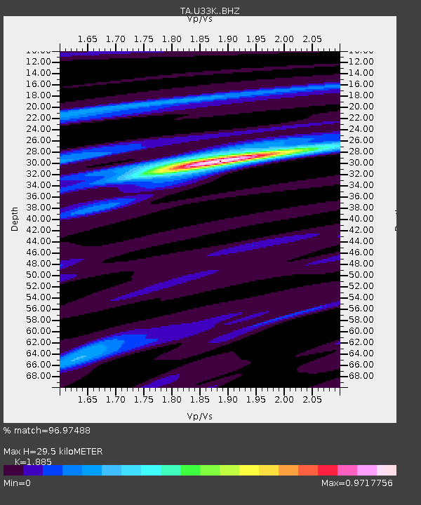
| Estimated Moho Depth: |
29.5 km |
| Estimated Crust Vp/Vs: |
1.88 |
| Assumed Crust Vp: |
6.597 km/s |
| Estimated Crust Vs: |
3.5 km/s |
| Estimated Crust Poisson's Ratio: |
0.30 |
|
| Radial Match: |
96.97488 % |
| Radial Bump: |
310 |
| Transverse Match: |
85.008415 % |
| Transverse Bump: |
400 |
| SOD ConfigId: |
11737051 |
| Insert Time: |
2019-04-26 06:06:15.138 +0000 |
| GWidth: |
2.5 |
| Max Bumps: |
400 |
| Tol: |
0.001 |
|

Signal To Noise
| Channel | StoN | STA | LTA |
| TA:U33K: :BHZ:20161208T17:50:49.674983Z | 17.391684 | 8.5979045E-6 | 4.9436875E-7 |
| TA:U33K: :BHN:20161208T17:50:49.674983Z | 3.862419 | 1.2143307E-6 | 3.1439643E-7 |
| TA:U33K: :BHE:20161208T17:50:49.674983Z | 8.448702 | 2.6878274E-6 | 3.1813497E-7 |
| Arrivals |
| Ps | 4.1 SECOND |
| PpPs | 13 SECOND |
| PsPs/PpSs | 17 SECOND |


