You are here: Home > Network List > TD - TransAlta Monitoring Network Stations List
> Station TD029 Z > Earthquake Result Viewer
TD029 Z - Earthquake Result Viewer
| Earthquake location: |
Solomon Islands |
| Earthquake latitude/longitude: |
-10.7/161.3 |
| Earthquake time(UTC): |
2016/12/08 (343) 17:38:46 GMT |
| Earthquake Depth: |
41 km |
| Earthquake Magnitude: |
7.8 mww |
| Earthquake Catalog/Contributor: |
NEIC PDE/us |
|
| Network: |
TD TransAlta Monitoring Network |
| Station: |
TD029 Z |
| Lat/Lon: |
52.22 N/115.20 W |
| Elevation: |
1164 m |
|
| Distance: |
94.4 deg |
| Az: |
37.809 deg |
| Baz: |
258.349 deg |
| Ray Param: |
0.041039165 |
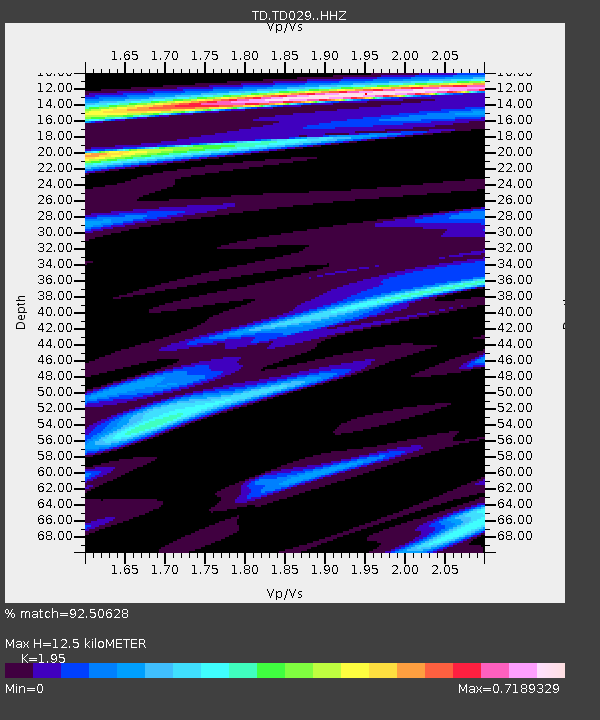
| Estimated Moho Depth: |
12.5 km |
| Estimated Crust Vp/Vs: |
1.95 |
| Assumed Crust Vp: |
6.426 km/s |
| Estimated Crust Vs: |
3.295 km/s |
| Estimated Crust Poisson's Ratio: |
0.32 |
|
| Radial Match: |
92.50628 % |
| Radial Bump: |
400 |
| Transverse Match: |
81.67665 % |
| Transverse Bump: |
400 |
| SOD ConfigId: |
11737051 |
| Insert Time: |
2019-04-26 06:06:23.439 +0000 |
| GWidth: |
2.5 |
| Max Bumps: |
400 |
| Tol: |
0.001 |
|

Signal To Noise
| Channel | StoN | STA | LTA |
| TD:TD029: :HHZ:20161208T17:51:30.450007Z | 6.020371 | 3.2417051E-6 | 5.3845605E-7 |
| TD:TD029: :HH1:20161208T17:51:30.450007Z | 2.192596 | 7.8908187E-7 | 3.5988475E-7 |
| TD:TD029: :HH2:20161208T17:51:30.450007Z | 2.059866 | 6.5841544E-7 | 3.1963992E-7 |
| Arrivals |
| Ps | 1.9 SECOND |
| PpPs | 5.6 SECOND |
| PsPs/PpSs | 7.5 SECOND |


