You are here: Home > Network List > CI - Caltech Regional Seismic Network Stations List
> Station MPM Manuel Prospect Mine, California, USA > Earthquake Result Viewer
MPM Manuel Prospect Mine, California, USA - Earthquake Result Viewer
| Earthquake location: |
Central Mid-Atlantic Ridge |
| Earthquake latitude/longitude: |
8.0/-39.2 |
| Earthquake time(UTC): |
2007/08/20 (232) 22:42:29 GMT |
| Earthquake Depth: |
10 km |
| Earthquake Magnitude: |
6.3 MB, 6.4 MS, 6.5 MW |
| Earthquake Catalog/Contributor: |
WHDF/NEIC |
|
| Network: |
CI Caltech Regional Seismic Network |
| Station: |
MPM Manuel Prospect Mine, California, USA |
| Lat/Lon: |
36.06 N/117.49 W |
| Elevation: |
185 m |
|
| Distance: |
75.8 deg |
| Az: |
305.093 deg |
| Baz: |
90.337 deg |
| Ray Param: |
0.051409755 |
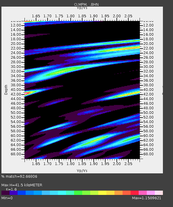
| Estimated Moho Depth: |
41.5 km |
| Estimated Crust Vp/Vs: |
1.60 |
| Assumed Crust Vp: |
6.279 km/s |
| Estimated Crust Vs: |
3.924 km/s |
| Estimated Crust Poisson's Ratio: |
0.18 |
|
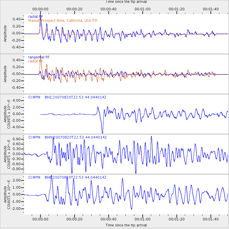
| Radial Match: |
92.66806 % |
| Radial Bump: |
395 |
| Transverse Match: |
87.4687 % |
| Transverse Bump: |
400 |
| SOD ConfigId: |
2564 |
| Insert Time: |
2010-03-05 20:19:54.133 +0000 |
| GWidth: |
2.5 |
| Max Bumps: |
400 |
| Tol: |
0.001 |
|
Signal To Noise
| Channel | StoN | STA | LTA |
| CI:MPM: :BHN:20070820T22:53:44.044014Z | 1.8635249 | 9.1524996E-8 | 4.911391E-8 |
| CI:MPM: :BHE:20070820T22:53:44.044014Z | 4.5820594 | 3.8697695E-7 | 8.4454804E-8 |
| CI:MPM: :BHZ:20070820T22:53:44.044014Z | 6.178406 | 7.524037E-7 | 1.2177959E-7 |
| Arrivals |
| Ps | 4.1 SECOND |
| PpPs | 17 SECOND |
| PsPs/PpSs | 21 SECOND |


