You are here: Home > Network List > UO - University of Oregon Regional Network Stations List
> Station DBO Dodson Butte, OR (UO CREST BB SMO) > Earthquake Result Viewer
DBO Dodson Butte, OR (UO CREST BB SMO) - Earthquake Result Viewer
| Earthquake location: |
Solomon Islands |
| Earthquake latitude/longitude: |
-10.7/161.3 |
| Earthquake time(UTC): |
2016/12/08 (343) 17:38:46 GMT |
| Earthquake Depth: |
41 km |
| Earthquake Magnitude: |
7.8 mww |
| Earthquake Catalog/Contributor: |
NEIC PDE/us |
|
| Network: |
UO University of Oregon Regional Network |
| Station: |
DBO Dodson Butte, OR (UO CREST BB SMO) |
| Lat/Lon: |
43.12 N/123.24 W |
| Elevation: |
984 m |
|
| Distance: |
86.8 deg |
| Az: |
45.216 deg |
| Baz: |
252.321 deg |
| Ray Param: |
0.043722603 |
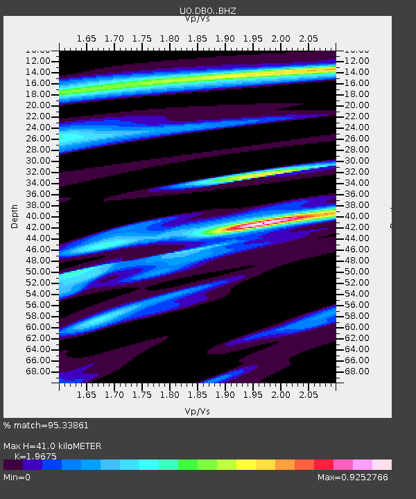
| Estimated Moho Depth: |
41.0 km |
| Estimated Crust Vp/Vs: |
1.97 |
| Assumed Crust Vp: |
6.522 km/s |
| Estimated Crust Vs: |
3.315 km/s |
| Estimated Crust Poisson's Ratio: |
0.33 |
|
| Radial Match: |
95.33861 % |
| Radial Bump: |
357 |
| Transverse Match: |
88.42059 % |
| Transverse Bump: |
400 |
| SOD ConfigId: |
11737051 |
| Insert Time: |
2019-04-26 06:06:34.954 +0000 |
| GWidth: |
2.5 |
| Max Bumps: |
400 |
| Tol: |
0.001 |
|

Signal To Noise
| Channel | StoN | STA | LTA |
| UO:DBO: :BHZ:20161208T17:50:55.220027Z | 11.321322 | 9.1065795E-6 | 8.0437417E-7 |
| UO:DBO: :BHN:20161208T17:50:55.220027Z | 1.4263887 | 1.2800219E-6 | 8.973865E-7 |
| UO:DBO: :BHE:20161208T17:50:55.220027Z | 2.9087946 | 3.2890548E-6 | 1.1307277E-6 |
| Arrivals |
| Ps | 6.2 SECOND |
| PpPs | 18 SECOND |
| PsPs/PpSs | 24 SECOND |


