You are here: Home > Network List > CI - Caltech Regional Seismic Network Stations List
> Station MPM Manuel Prospect Mine, California, USA > Earthquake Result Viewer
MPM Manuel Prospect Mine, California, USA - Earthquake Result Viewer
| Earthquake location: |
Near Coast Of Peru |
| Earthquake latitude/longitude: |
-13.4/-76.6 |
| Earthquake time(UTC): |
2007/08/15 (227) 23:40:57 GMT |
| Earthquake Depth: |
39 km |
| Earthquake Magnitude: |
6.7 MB, 7.9 MS, 8.0 MW, 7.5 ME |
| Earthquake Catalog/Contributor: |
WHDF/NEIC |
|
| Network: |
CI Caltech Regional Seismic Network |
| Station: |
MPM Manuel Prospect Mine, California, USA |
| Lat/Lon: |
36.06 N/117.49 W |
| Elevation: |
185 m |
|
| Distance: |
62.5 deg |
| Az: |
323.287 deg |
| Baz: |
134.112 deg |
| Ray Param: |
0.060095757 |
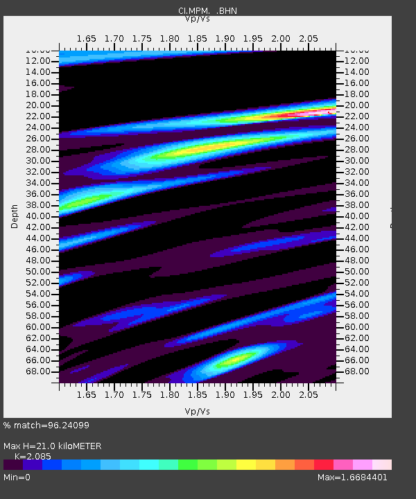
| Estimated Moho Depth: |
21.0 km |
| Estimated Crust Vp/Vs: |
2.09 |
| Assumed Crust Vp: |
6.279 km/s |
| Estimated Crust Vs: |
3.011 km/s |
| Estimated Crust Poisson's Ratio: |
0.35 |
|
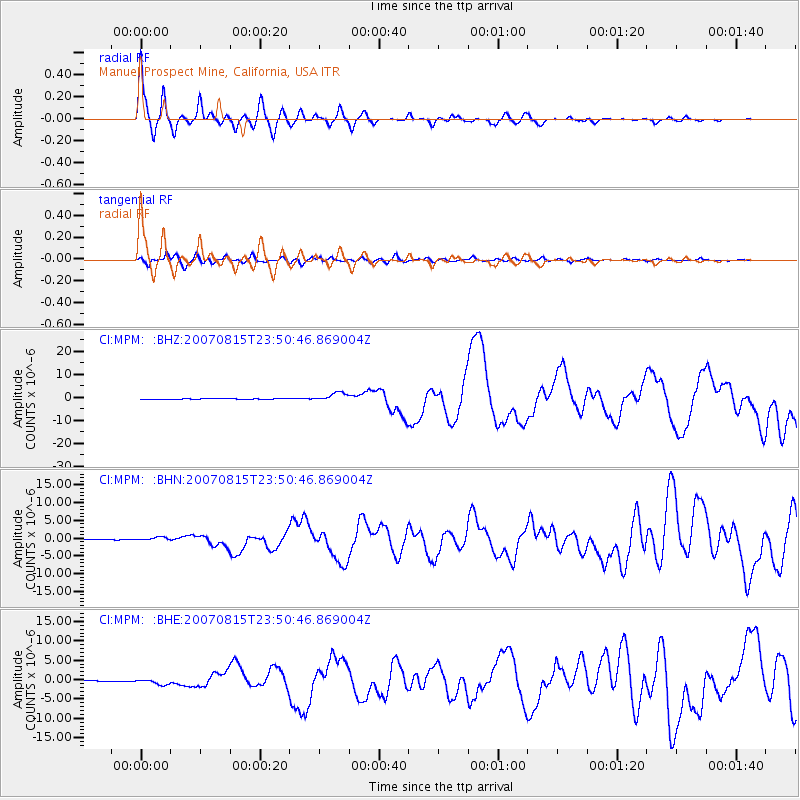
| Radial Match: |
96.24099 % |
| Radial Bump: |
400 |
| Transverse Match: |
81.0415 % |
| Transverse Bump: |
400 |
| SOD ConfigId: |
2564 |
| Insert Time: |
2010-03-05 20:19:58.596 +0000 |
| GWidth: |
2.5 |
| Max Bumps: |
400 |
| Tol: |
0.001 |
|
Signal To Noise
| Channel | StoN | STA | LTA |
| CI:MPM: :BHN:20070815T23:50:46.869004Z | 6.2110443 | 5.769074E-7 | 9.288412E-8 |
| CI:MPM: :BHE:20070815T23:50:46.869004Z | 7.115772 | 6.825767E-7 | 9.592447E-8 |
| CI:MPM: :BHZ:20070815T23:50:46.869004Z | 18.020643 | 1.9545168E-6 | 1.0845988E-7 |
| Arrivals |
| Ps | 3.8 SECOND |
| PpPs | 10.0 SECOND |
| PsPs/PpSs | 14 SECOND |


