You are here: Home > Network List > UW - Pacific Northwest Regional Seismic Network Stations List
> Station FISH Seaside, OR, USA > Earthquake Result Viewer
FISH Seaside, OR, USA - Earthquake Result Viewer
| Earthquake location: |
Solomon Islands |
| Earthquake latitude/longitude: |
-10.7/161.3 |
| Earthquake time(UTC): |
2016/12/08 (343) 17:38:46 GMT |
| Earthquake Depth: |
41 km |
| Earthquake Magnitude: |
7.8 mww |
| Earthquake Catalog/Contributor: |
NEIC PDE/us |
|
| Network: |
UW Pacific Northwest Regional Seismic Network |
| Station: |
FISH Seaside, OR, USA |
| Lat/Lon: |
45.93 N/123.56 W |
| Elevation: |
325 m |
|
| Distance: |
87.5 deg |
| Az: |
42.468 deg |
| Baz: |
251.963 deg |
| Ray Param: |
0.04325698 |
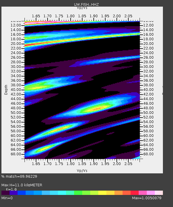
| Estimated Moho Depth: |
11.0 km |
| Estimated Crust Vp/Vs: |
1.60 |
| Assumed Crust Vp: |
6.566 km/s |
| Estimated Crust Vs: |
4.104 km/s |
| Estimated Crust Poisson's Ratio: |
0.18 |
|
| Radial Match: |
89.96229 % |
| Radial Bump: |
400 |
| Transverse Match: |
89.104225 % |
| Transverse Bump: |
346 |
| SOD ConfigId: |
11737051 |
| Insert Time: |
2019-04-26 06:06:54.171 +0000 |
| GWidth: |
2.5 |
| Max Bumps: |
400 |
| Tol: |
0.001 |
|
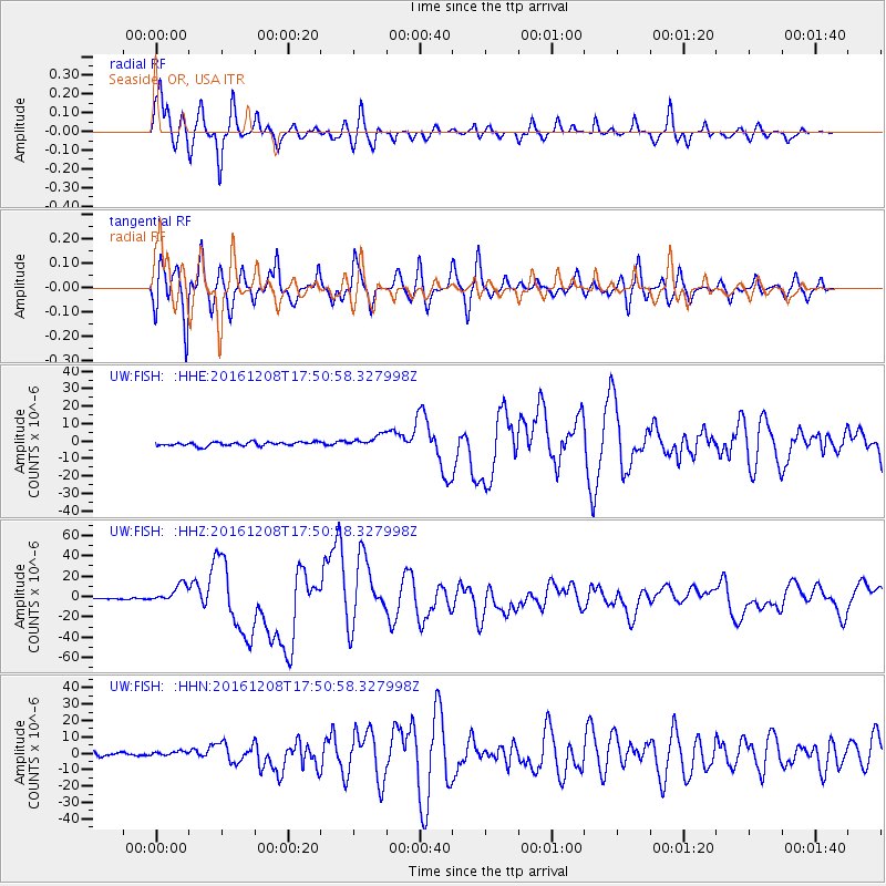
Signal To Noise
| Channel | StoN | STA | LTA |
| UW:FISH: :HHZ:20161208T17:50:58.327998Z | 11.971188 | 9.020228E-6 | 7.534948E-7 |
| UW:FISH: :HHN:20161208T17:50:58.327998Z | 1.3562167 | 1.5358694E-6 | 1.1324661E-6 |
| UW:FISH: :HHE:20161208T17:50:58.327998Z | 3.1973786 | 3.4862544E-6 | 1.0903476E-6 |
| Arrivals |
| Ps | 1.0 SECOND |
| PpPs | 4.2 SECOND |
| PsPs/PpSs | 5.3 SECOND |


